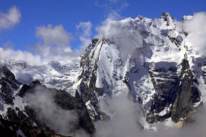
The highest mountains in the world are more than 8 kilometers in height - these are peaks that are impressive. Passenger planes fly at this altitude (8-12 kilometers). In fact, there are many more such mountains than fourteen. But only those that are separated from each other by a significant distance are taken into account. All major eight-thousanders are located in Central Asia. Nepal, China, Pakistan, India. I wonder if this is the will of the gods or is it connected to something?
Not everyone can conquer at least one peak of the “14 gods”, but there are those on our planet who strive to conquer all fourteen! At the moment there were only 41 people, out of more than 9 billion people on the planet. It’s hard to say why height attracts them, perhaps with only one thing: “...height, height, height...”.
It should be added that there is such a thing as “pure ascent,” that is, climbers made the ascent without using oxygen masks. For reference, even commercial airliners often fly regularly at lower altitudes.
More than 10 thousand ascents have been made to the great 8 thousand peaks.
About 7 percent of all climbs ended tragically. The bodies of many dead climbers remained at the heights they had not conquered, due to the difficulty of evacuating them. Some of them serve as landmarks for modern conquerors of certain heights. For example, the height of 8500 meters on Everest for 17 years greeted climbers with the body of Tsewang Palzhor, who died on it in 1996. It even received an unofficial name - “Green Shoes”, this is the exact color of the shoes the deceased climber was wearing. Why are we so attracted by unconquered heights? Everyone has their own answer to this question.
Another known name is Chomolungma (from Tibetan “ Chomolangma" means "Divine" or "Mother". The highest point in the world and the most “prestigious” peak on our “blue” planet. Its height is 8848 meters above sea level. Its English name “Everest” was given in honor of the head of the British Indian Geodetic Survey, Sir George Everest.
Where is Everest
Everest is located on several hundred square kilometers, on the territory of mainly two states - Nepal and China. Chomolungma is part of the Himalaya mountain system, the Mahalangur Himal range (in the part called the Khumbu Himal). Perhaps no other peak on our planet attracts people to conquer it like Chomolungma.
Climbing Everest
The mountain was first conquered on May 29, 1953 by Sherpa Tenzing Norgay and New Zealander Edmund Hillary.
Since the “ascending travelers” were counted, about three hundred people have already died. Even the most modern equipment and equipment do not allow all the thirsty inhabitants of our planet to conquer this height.
About five thousand people try to conquer Everest every year. By 2018, more than 8,400 climbers managed to reach the summit, almost three and a half thousand of them climbed Everest more than once.
Climbing Everest takes about 2 months - with acclimatization and setting up camps. Climbers lose on average 10-15 kilograms of their weight during this time.
The most dangerous section of the climb is considered to be the last 300 meters to the top. Not all climbers can overcome this part. At the top there are often strong winds of up to 200 km/h. And the temperature throughout the year ranges from 0°C to -60°C.


Second highest mountain in the world, Chogori (K2)
Chogori (second name K2) is the second highest peak on the planet, but climbing it is considered much more difficult. Moreover, in winter, no one managed to conquer it at all, and the mortality rate when climbing this peak is the highest and amounts to 25%. Only a few hundred climbers managed to conquer this height.
In 2007, it was Russian climbers who managed to climb the most difficult section of the peak, the Western Wall, and they did it without the use of oxygen equipment. The most massive conquest of Chogori took place in the summer of 2018. Of the group, which consisted of 63 people, one died. At the same time, Andrzej Bargiel became the first climber to ski down from the top of this mountain.

Kanchenjunga
Kanchenjaga is the third highest eight-thousander on the planet. Located in the Himalayas. Until the mid-19th century, it was considered the highest mountain peak, but now, after calculations, it ranks third in height. At the moment, more than ten climbing routes to this peak have been laid. Translated from Tibetan, the name of the mountain means “treasury of the five great snows.”
Due to its location, Kanchenjaga partially belongs to the national park of the same name in India. If you look at the mountain from India, you will notice that there are five peaks in this mountain range. Moreover, four out of five peaks rise to a height of more than eight thousand meters. Their combination forms a very colorful landscape, so this mountain is considered the most picturesque among its kind. One of the favorite places of creation of Nicholas Roerich.
The first conquest of this peak belongs to the English climbers Joe Brown and George Bend. It was committed on May 25, 1955. In Nepal, for a long period of time, there was a legend about Kanchenjaga - a mountain woman who does not allow the fair sex to conquer her peak. Only in 1998 did the British Ginette Harrison manage to do this. The general trend towards a decrease in the mortality rate when conquering mountain peaks unfortunately did not affect Kanchenjaga and is 22 percent.

Lhotse
Lhotse, a mountain peak on the border of China and Nepal, has an altitude of 8516 meters. The mountain is located in close proximity to Chomolungma, the distance between them does not exceed 3 kilometers. They are separated by the South Col pass, the highest point of which almost reaches eight thousand. Such proximity of two great peaks creates a very majestic picture. From a certain angle you can see that Lhotse is like a triangular pyramid. Moreover, at the moment there is the smallest number of climbing routes for each of these three faces. This is largely due to the fact that the slopes of the peaks are very steep, and the likelihood of avalanches is extremely high.
Unlike Chogori, this peak was still conquered in winter. It is worth noting that so far none of the individual climbers or groups have been able to climb the traverse of all three peaks of this eight-thousander. The Eastern Wall of Lhotse also remains unconquered.

Makalu
Makalu is an unusually beautiful peak, but extremely difficult to climb. Less than 30% of organized expeditions ended in success. The mountain is located on the border of China and Nepal, a little more than 20 km southeast of Everest.
The mountain did not attract much attention for more than a hundred years after it was marked on maps. This is largely due to the desires of previous expeditions to conquer higher peaks located in close proximity to it. The peak was first conquered only in 1955.
In certain circles the mountain is known as the “black giant”. This name was assigned to it due to the fact that the extremely sharp ribs of the peak do not allow snow to settle on them, and it often appears before its contemplators as black granite rocks. Since the mountain is located on the border of two eastern countries, its conquest is related to mystical factors, supposedly the mountain itself decides which of the expeditions is allowed to climb and who is not worthy of this fact.

Cho Oyu
The height of Cho Oyu is a little over 8200 meters. Near the peak lies the Nangpa-La pass, through which the main “trade route” of the Sherpas from Nepal to Tibet passes. Thanks to this route, many climbers consider this peak to be the most accessible of all eight-thousanders, although this is not entirely true. Just on the Nepal side there is a very steep and complex wall, so most of the ascents are carried out from the Tibet side.
The weather in the Cho Oyu area is almost always favorable for climbing, and its “accessibility” makes this peak like a springboard before climbing Everest.

Dhaulagiri I
The number one perfectly reflects the essence of the name of the mountain; it consists of many ridges, the highest of which reaches a height of 8167 meters. It is believed that the mountain has 11 peaks, of which only one is higher than 8000 meters, the rest lie between 7 and 8 kilometers. Dhaulagiri is located in the central part of Nepal and belongs to the Main Himalayan Range.
Despite the complexity of the name, it is translated very simply as “white mountain”. The history of its conquest is interesting. Until the 30s of the 19th century, it was considered the highest mountain on the planet. But they started conquering the peak only in the middle of the last century. For a long time it was impregnable, only the eighth expedition managed to reach the top. Like its other brothers, this peak has its own simpler routes and very inaccessible slopes.

Manaslu
The mountain is located in the northern part of Nepal and reaches a height of 8163 meters. Due to its relative seclusion, this peak looks extremely majestic against the backdrop of the surrounding splendor. Maybe this explains its name, which means “mountain of spirits.” For a long time, climbing the mountain was difficult due to hostile local residents (the name of the mountain speaks about this). Avalanches often fell on local settlements, and only after long offerings to the highest gods did the Japanese expedition finally manage to conquer this peak. The mortality rate among climbers conquering Manaslu reaches almost 18 percent.
The mountain itself and its surroundings are part of the Nepal National Park of the same name. The indescribable beauty of the park prompted the country's authorities to create a walking route for lovers of mountain recreation.

Nanga Parbat (Nanga Parbat)
One of the few eight-thousanders located not in China or Nepal, but in territory controlled by Pakistan. There are four main peaks on the mountain, the highest of which is 8125 meters. The top of the mountain is among the top three in terms of the number of deaths during its conquest.
In terms of the history of the ascent, an interesting fact is that it was on this mountain that the first attempt to climb an eight-thousander was made. This happened back in 1895. The first conquest of the peak alone, and not as part of a prepared expedition, is associated with this mountain. There are beliefs that it was here that the symbols of Nazi Germany, whose representatives, as we know, were close to the occult sciences, were first noticed.
Certain difficulties in planning expeditions to this peak are caused by internal political disagreements on the territory of Pakistan.

Annapurna I is the most dangerous peak among eight-thousanders
Annapurna I is the first of the eight-thousander peaks, whose height is already below 8100 meters (officially 8091 meters). However, for all the years of climbing taken into account, she has the highest mortality rate among conquerors, almost one in three (32%). Although at present it is steadily declining from year to year. Annapurna is located in central Nepal and the entire mountain range stretches for more than 50 kilometers. Consists of many ridges of varying heights. From the highest points of Annapurna you can observe another giant - Jaulaguri, about 30 kilometers between them.
If you fly near these mountains by plane, you will see a majestic view of the nine main ridges of this massif. It is part of the national park of the same name, located in Nepal. There are several hiking routes along it, along which indescribable views of the Annapurna peaks open.

Gasherbrum I
The summit of Gasherbrum I is part of the Baltoro Muztagh mountain range. Its height is 8080 meters and it is the eleventh eight-thousander on the planet. It is located in Pakistan-controlled territory near the border with China. Translated it means “beautiful mountain”. It also has another name - Hidden Peak, which translated from English means hidden peak. In general, the Karakoram mountain system, to which Gasherbrum belongs, has seven peaks, and three of them exceed 8 thousand meters, although not by much.
The first ascent of the peak dates back to 1958, and in 1984 the famous climber Reinhold Messner makes a traverse between Gasherbrum I and Gasherbrum II.

Broad Peak
The second highest peak in Karakurum, the middle brother between the two sisters Gasherbrum I and Gasherbrum II. In addition, literally 8 kilometers from Broad Peak there is another high relative - Mount Chogori. The first ascent of Broad Peak took place a year earlier than neighboring Gasherbrum I, in 1957
It itself consists of two peaks – Pre-summit and Main (8047 meters). The southwestern slopes are much easier than the opposite, northeastern ones, and it is on them that the classic routes to the Main Peak are laid.

Gasherbrum II
Just below Broad Peak there is another peak among the eight-thousanders - Gasherbrum II (height 8035 meters). Either its relative lowness affected it, or for another reason, but the first ascent to this peak dates back to a year earlier than on Broad Peak, in 1956. The main routes of peak conquerors pass along its southwestern slope. It is least susceptible to mountain falls and avalanches. It is used by many climbers who begin to conquer everything above 8 kilometers.
This mountain fully justifies its name; in good weather, the boundaries between gray and black limestone rocks are clearly visible, corresponding to different age boundaries, which, in combination with crystal clear snow, creates unique landscapes.

Shishabangma
The majestic iceberg with a height of 8027 meters is the lowest of all known eight-thousanders. Located in the Himalayas, in China. It consists of three peaks, two of which - Main and Central (8008 meters) exceed 8 kilometers. Translated from the Tibetan language it means “harsh climate”.
The first conquest of this peak was made by a Chinese expedition in May 1964. It is considered one of the least difficult peaks, although more than 20 climbers have died on its slopes over the past years.

The highest mountains in the world on the world map
This is a brief overview of all 14 eight-thousanders on the planet. Each mountain is unique in its own way and the saying applies to each of them: “only mountains can be better than mountains.”
There are many high mountains in the world that climbers have managed to conquer. However highest mountain in the world remained unconquered for a long time.
The highest mountain in the world
The highest mountain in the world is Chomolungma (Everest). Its height is 8,848 m above sea level.
In this case, it is worth paying attention to the clarification “above sea level”, since if you measure the height of the mountain from the core, then the record will belong to the extinct Chimborazo, which is in.
Everyone knows that our planet has the shape of an ellipse. It follows from this that mountains located near the equator are higher than in other areas of the Earth.
 Height from the center of the earth
 In this regard, Chimborazo is located closer to the convex center of the Earth than any other mountains, including Everest.
The most difficult mountain for climbers
Considering all the above facts, the question inevitably arises: why is Everest the most popular mountain in the world, while Ecuadorian Chimborazo (6384 m) remains in the shadows?
This is largely due to the difficulties in climbing Chomolungma.
Let's imagine that we want to conquer both of these peaks.
Climbing Chomolungma
In order to climb Everest, you will first have to reach the base camp.
This part of the journey will take you about 10 days. After this, it will take another month and a half for acclimatization alone!
 View of Everest from an airplane
 Then you will have to climb directly to the top for about 9 more days. And this is the most difficult part of the path.
Climbing Chimborazo
Now let's imagine how long it will take to conquer Chimborazo.
When climbing, acclimatization will take you no more than 2 weeks, and the journey to the top will not exceed 2 days.
 Chimborazo
 From all that has been said, we can conclude that after Everest, climbing the Ecuadorian peak will seem like an evening walk to you.
"Above" and "below" sea level
So, Everest is the highest point on the planet above sea level.
However, speaking of the tallest mountain in the world, and taking into account some other factors, it is appropriate to remember another mountain.
If you measure the absolute height from the base to the top, then the highest mountain will be Mauna Kea, located in the territory.
 Mauna Kea
 It may be difficult for some to understand what we are talking about, so let's sort out this confusion one by one.
Unlike Everest, most of Mauna Kea lies below the surface of the water.
Thus, if we measure the height from the base (underwater) to the top, it will be 10203 m, which is 1355 m higher than Chomolungma.
 Everest and Mauna Kea
 Mauna Kea is an extinct volcano that last erupted approximately 4,600 years ago. An interesting fact is that there are 13 telescopes on the top of this mountain.
This is due to the fact that there is a very low level of humidity and clear skies. Thanks to this, astronomers can monitor celestial objects while studying outer space.
The highest mountains on each continent
- Europe – (5,642 m)
- – Kilimanjaro (5,895 m)
- Asia – Everest (8,848 m)
- – Aconcagua (6,962 m)
- North America – McKinley (6,190 m)
- – Vinson massif (4,892 m)
- – Kosciuszko (2,228 m)
Now let's return again to the highest mountain in the world - Chomolungma, and learn not only its geographical features, but also how man conquered it.
Chomolungma is located on the Mahalangur Himal ridge in. It occupies such a large area that its base is located on the territory of the Tibet Autonomous Region.
Over the centuries, the mountain has attracted the attention of many people who wanted to be at its peak. As a result, hundreds of climbers who tried to conquer Chomolungma died.
Attempts to conquer Chomolungma
It is officially believed that Briton George Mallory was the first climber to attempt to climb the mountain. However, he and his partner failed to achieve their goal.
They died on one of the slopes of Chomolungma back in 1924. It is interesting that their bodies were discovered only in 1999. According to experts, they were only 200 m short of conquering the mountain peak.

After this expedition, many more daredevils tried to reach the peak of Everest, but they all either died or returned back, not daring to set foot on the most dangerous sections of the path.
As mentioned earlier, climbing Mount Qomolungma is accompanied by many different difficulties:
- High atmospheric rarefaction (lack of oxygen);
- Low temperature (below -50°C);
- Hurricane winds, as a result of which the human body feels frosts down to -120°C;
- Solar ;
- Frequent avalanches, steep slopes, falling into crevices.
First ascent of the highest mountain in the world
When did the first successful ascent of the highest mountain on earth take place?
And this happened a little more than half a century ago.
On May 29, 1953, New Zealander Edmund Hillary, together with Sherpa Tenzing Norgay, were able to conquer Everest, as a result of which they became the first people to reach its summit.
It is worth noting that before setting off on the expedition, they carefully prepared for it.
The climbers took oxygen equipment with them and chose the most convenient route. Having reached an altitude of 8500 m, they set up a tent for the night.
The climbers woke up in the morning to find their boots covered in ice.
It took them about 2 hours to defrost their shoes and make the final push to conquer Everest.
A few hours later they were already at the top, where they spent about 15 minutes. During this time, the climbers took several photographs and planted a flag.
Having descended to earth, they immediately became real heroes. The entire world press wrote about their feat, wanting to know all the details of the expedition.
In subsequent years, Qomolungma was conquered by climbers from different countries. The first woman to reach its peak was Japanese Junko Tabei (1976).
Despite the fact that today hundreds of people continue to die on Everest, this mountain still arouses the greatest interest among extreme sports enthusiasts.
It is curious that Chomolungma was conquered in a variety of ways. They climbed it without oxygen masks, descended from its peak on skis and snowboards, and also competed in the time spent on its ascent.
 View of the northern wall of Qomolangma from the path leading to base camp
 An interesting fact is that the youngest person to visit the highest mountain in the world was a 13-year-old Indian girl, Purna Malavath, and the oldest person was 72-year-old American Bill Berg.
According to official data, more than 260 people died on the slopes of the mountain, and about 8,300 climbers have already conquered the peak of Chomolungma.
Who knows what other records will be set in the future, but it is safe to say that Everest will forever remain the most popular mountain in the world.
Now you know what the highest mountain in the world is. If you liked this article, share it on social networks.
If you like it, subscribe to the site IinterestingFakty.org. It's always interesting with us!
Did you like the post? Press any button.
There are fourteen mountain peaks on Earth with a height of more than eight thousand meters. All these peaks are located in Central Asia. But most of the highest mountain peaks are in the Himalayas.
They are also called the “roof of the world.” Climbing such mountains is a very dangerous activity. Until the middle of the last century, it was believed that mountains above eight thousand meters were inaccessible to humans.
We have compiled a ranking of ten, which includes the highest mountains in the world.
It is also customary to distinguish 7 highest mountain peaks in the world, one for each part of the world. Climbers who have conquered all these mountains are members of the honorable Seven Summits Club.
There are 2 main lists of the seven peaks of the world. More difficult to climb is the list compiled by Italian climber Reinhold Messner. In this list, in addition to Asia, Europe, South and North America, Africa, Antarctica, not Australia, but Australasia appears as a part of the world, i.e. a region that includes Australia, New Guinea, New Zealand and their adjacent Pacific Islands. Accordingly, instead of the highest peak in Australia - Mount Kosciuszko, whose height is only 2228 meters and which is very easy to conquer, the list includes Mount Jaya in New Guinea, whose height is 4884 meters and which was first conquered only in 1962. The list compiled by American mountaineer Richard Bass is more traditional from the point of view of Russian geography; it includes Australia rather than Australasia as a part of the world.
Thus, the highest peaks in the world become not seven, but eight. In some interpretations there are even nine of them, because Geographers still disagree about the border between Europe and Asia, so the highest peak in Europe is either Elbrus in the Russian Caucasus or Mont Blanc in the Alps.
TOP 10 HIGHEST MOUNTAINS IN THE WORLD:
Annapurna - 8091 m .jpg)
This peak opens the top ten highest mountains on our planet. Annapurna is very famous and famous, it is the first Himalayan eight-thousander to be conquered by people. People first climbed to its summit back in 1950. Annapurna is located in Nepal, its peak height is 8091 meters.
The mountain has as many as nine peaks, one of which (Machapuchare) has never been touched by a human foot. Locals consider this peak to be the sacred abode of Lord Shiva. Therefore, climbing it is prohibited. The highest of the nine peaks is called Annapurna 1. Annapurna is very dangerous; climbing to its peak has claimed the lives of many experienced climbers.
Nanga Parbat - 8125 m
This mountain is the ninth highest on our planet. It is located in Pakistan and has a height of 8125 meters. The second name of Nanga Parbat is Diamir, which translates as “Mountain of the Gods”. They were able to conquer it for the first time only in 1953. Six unsuccessful attempts were made to reach the summit. A lot of climbers died while trying to climb this mountain peak.
In terms of mortality among climbers, it ranks sadly third after K-2 and Everest. This mountain is also called the “killer”.
Manaslu - 8156 m .jpg)
This eight-thousander ranks eighth on our list of the highest mountains in the world. It is also located in Nepal and is part of the Mansiri Himal mountain range.
The height of the peak is 8156 meters.
The top of the mountain and the surrounding area are very picturesque. It was first conquered in 1956 by a Japanese expedition. Tourists love to come here. But to conquer the peak you need a lot of experience and excellent preparation. 53 climbers died while trying to climb Manaslu.
Dhaulagiri - 8167 m
A mountain peak located in the Nepalese part of the Himalayas. Its height is 8167 meters. The name of the mountain is translated from the local language as “white mountain”. Almost all of it is covered with snow and glaciers. Dhaulagiri is quite difficult to climb. They were able to conquer it in 1960. Climbing this peak took the lives of 58 experienced (others do not go to the Himalayas) climbers.
Cho Oyu - 8201 m
Another Himalayan eight-thousander, which is located on the border of Nepal and China. The height of this peak is 8201 meters. It is considered not too difficult to climb, but despite this, it has already claimed the lives of 39 climbers and ranks sixth on our list of the highest mountains on our planet.
Makalu - -8485 m .jpg)
The fifth highest mountain in the world is Makalu, the second name of this peak is the Black Giant. It is also located in the Himalayas, on the border of Nepal and China and has an altitude of 8485 meters. It is located nineteen kilometers from Everest. This mountain is incredibly difficult to climb; its slopes are very steep.
Only a third of expeditions that aim to reach its summit succeed. 26 climbers died while climbing this peak.
Lhotse - 8516 m
Another mountain located in the Himalayas and having a height of more than eight kilometers. Lhotse is located on the border between China and Nepal. Its height is 8516 meters. It is located at a distance of three kilometers from Everest. They were able to conquer this mountain for the first time only in 1956.
Lhotse has three peaks, each of them over eight kilometers in height. This mountain is considered one of the highest, most dangerous and difficult peaks to climb.
Kanchenjunga - 8585 m
This mountain peak is also located in the Himalayas, between India and Nepal. It is the third highest mountain peak in the world: the peak height is 8585 meters. The mountain is very beautiful, it consists of five peaks. The first ascent of it took place in 1954.
The conquest of this peak cost the lives of forty climbers.
Chogori (K-2) - 8614 m .jpg)
Chogori is the second highest mountain in the world. Its height is 8614 meters. K-2 is located in the Himalayas, on the border of China and Pakistan. Chogori is considered one of the most difficult mountain peaks to climb; it was only conquered in 1954.
Of the 249 climbers who visited its summit, 60 people died. This mountain peak is very picturesque.
Everest (Qomolungma) - 8848 m .jpg)
This mountain peak is located in Nepal. Its height is 8848 meters. Everest is the highest mountain peak of the Himalayas and our entire planet. Everest is part of the Mahalangur Himal mountain range.
This mountain has two peaks: northern (8848 meters) and southern (8760 meters). The mountain is stunningly beautiful: it has the shape of an almost perfect triangular pyramid. It was possible to conquer Chomolungma only in 1953. 210 climbers died during attempts to climb Everest.
Nowadays, climbing along the main route no longer poses any special problems, however, at high altitudes, daredevils can expect a lack of oxygen (there is almost no fire here), heavy winds and low temperatures (below sixty degrees). To conquer Everest you need to spend at least $8,000.

As a rule, the highest peaks of the Sikhote-Alin have a sharply defined contour and are covered in large areas with large stone placers. The relief forms resemble heavily destroyed circuses and carts of mountain glaciation.
They are composed of sand and shale deposits with numerous intrusion breakthroughs, which led to the presence of deposits of gold, tin and base metals. In tectonic depressions within the Sikhote-Alin there are deposits of hard and brown coal.
Basalt plateaus are common in the foothills, of which the largest plateau in area is to the west of Sovetskaya Gavan. Plateau areas are also found on the main watershed. The largest is the Zevin plateau, on the watershed of the upper reaches of Bikin and the rivers flowing into the Tatar Strait. In the south and east, Sikhote-Alin consists of steep mid-mountain ridges, in the west there are numerous longitudinal valleys and basins, and at altitudes of more than 900 m there are chars. In general, Sikhote-Alin has an asymmetrical transverse profile. The western macroslope is flatter than the eastern one. Accordingly, rivers flowing to the west are longer. This feature is reflected in the very name of the ridge. Translated from the Manchu language - the ridge of large western rivers.
No. Mountain Height above sea level (m)
1 Tordoki-Yani 2090 Khabarovsk Territory, Nanaisky district
2 Ko 2003 Khabarovsk Territory, district named after. Lazo
3 Yako-Yani 1955 Khabarovsk Territory
4 Anik 1933 Primorsky Krai, Pozharsky district
5 Durhe 1903 Khabarovsk Territory, district named after. Lazo
6 Oblachnaya 1855 Primorsky Krai, Chuguevsky district
7 Bolotnaya 1814 Primorsky region, Pozharsky district
8 Sputnik 1805 Khabarovsk Territory, district named after. Lazo
9 Acute 1788 Primorsky Krai, Terneysky district
10 Arsenyeva 1757 Primorsky region, Pozharsky district
11 High 1745 Primorsky Krai,
12 Snezhnaya 1684 Primorsky region, Chuguevsky district
13 Olkhovaya 1668 Primorsky Krai, Partizansky district
14 Lysaya 1554 Primorsky Krai, Partizansky/Lazovsky districts
15 Taunga 1459 Khabarovsk region
16 Izyubrinaya 1433 Primorsky Krai

The internal ridge is significantly lower than the Main Ridge (up to 600 - 760 m above sea level). It stretches parallel to the Main River and is separated from it by an interridge depression of 10 - 25 km. In some places there are isolated low mountains and short ridges with flat tops, formed during the erosion of the Inner Ridge. These are the remnant mountains of Mangup, Eski-Kermen, Tepe-Kermen and others - natural bastions on which fortified cities were built in the Middle Ages.

It is about 250 m above sea level, the maximum is 325 m. It lies north of Inner and is separated from it by a depression 3 to 8 km wide. The outer ridge is most clearly expressed between Simferopol and Sevastopol. It gradually decreases to the north and imperceptibly passes into the Plain Crimea.
The Inner and Outer ridges are not only lower than the Main Ridge, but are also distinguished by a flat, even surface, slightly inclined to the northwest. They form the foothills of the Crimean Mountains.
There are two regions on the Kerch Peninsula, delimited by the low Parpach ridge. In the southwest it is an undulating plain with various isolated hills, in the northeast it is a hilly ridge terrain.
The soils of Crimea are very diverse. Each physical-geographical region is characterized by its own species. In the Sivash region, solonetsic and solonetzic soils predominate; to the south, in the flat part of the peninsula, there are chestnut soils and the so-called southern chernozem (heavy loamy and clayey with underlying loess-like rocks); mountain meadow and mountain chernozems were formed on the yailas; On the forested slopes of the Main Ridge, brown mountain forest soils are common. special brown soils, similar to subtropical red soils.
The name Tien Shan means “heavenly mountains” in Chinese. As E.M. Murzaev reports, this name is a tracing from the Turkic Tengritag, formed from the words: Tengri (Sky, God, divine) and tag (mountain).
The Tien Shan system includes the following orographic regions:
Northern Tien Shan: Ketmen, Trans-Ili Alatau, Kungei-Alatau and Kyrgyz ridges;
Eastern Tien Shan: ridges Borokhoro, Iren-Khabyrga, Bogdo-Ula, Karlyktag Halyktau, Sarmin-Ula, Kuruktag
Western Tien Shan: Karatau, Talas Alatau, Chatkal, Pskem and Ugam ranges;
Southwestern Tien Shan: ridges framing the Fergana Valley and including the southwestern slope of the Fergana Range;
Inner Tien Shan: bounded from the north by the Kyrgyz ridge and the Issyk-Kul basin, from the south by the Kokshaltau ridge, from the west by the Fergana ridge, from the east by the Akshiyrak mountain range.
The Tien Shan Mountains are considered one of the highest in the world, among them there are more than thirty peaks over 6000 meters high. The highest point of the mountain system is Pobeda Peak (Tomur, 7439 m), located on the border of Kyrgyzstan and the Xinjiang Uyghur Autonomous Region of China; the next highest is Khan Tengri Peak (6995 m) on the border of Kyrgyzstan and Kazakhstan.
Three mountain ranges diverge from the Central Tien Shan to the west, separated by intermountain basins (Issyk-Kul with Lake Issyk-Kul, Naryn, At-Bashyn, etc.) and connected in the west by the Fergana Range.

In the Eastern Tien Shan there are two parallel mountain ranges (height 4-5 thousand m), separated by depressions (height 2-3 thousand m). Characterized by highly elevated (3-4 thousand m) leveled surfaces - syrts. The total area of glaciers is 7.3 thousand km², the largest is South Inylchek. Rapids rivers - Naryn, Chu, Ili, etc. Mountain steppes and semi-deserts predominate: on the northern slopes there are meadow-steppes and forests (mainly coniferous), higher up there are subalpine and alpine meadows, on the syrts there are so-called cold deserts.
From west to east it is 2500 km. Mountain system in Sr. and Center. Asia. Length from 3. to E. 2500 km. Alpine folding and the remains of ancient leveled surfaces were preserved at an altitude of 3000-4000 m in the form of syrts. Modern tectonic activity is high, earthquakes are frequent. Mountain ranges are composed of igneous rocks, basins are composed of sedimentary rocks. Deposits of mercury, antimony, lead, cadmium, zinc, silver, and oil in the basins.
The relief is predominantly high-mountainous, with glacial forms, screes, and permafrost is common above 3200 m. There are flat intermountain basins (Fergana, Issyk-Kul, Naryn). The climate is continental, temperate. Snowfields and glaciers. The rivers belong to the internal drainage basins (Naryn, Ili, Chu, Tarim, etc.), lake. Issyk-Kul, Song-Kel, Chatyr-Kel.
The first European explorer of the Tien Shan in 1856 was Pyotr Petrovich Semyonov, who received the title “Semyonov-Tian-Shansky” for his work.

PUTIN PEAK
Prime Minister of Kyrgyzstan Almazbek Atambayev signed a decree naming one of the Tien Shan peaks after Russian Prime Minister Vladimir Putin.
“The height of this peak reaches 4,500 meters above sea level. It is located in the Ak-Suu river basin, in the Chui region,” the office of the head of the Kyrgyz government said.
One of the Tien Shan peaks in the Issyk-Kul region of Kyrgyzstan is named after the first president of Russia, Boris Yeltsin.
Mount Zugspitze - the highest mountain in Germany
Bavaria does not claim to be the “roof of the world”. But even here in Bavaria, snow-capped cliff tops, even in summer, are the norm. For example, Mount Zugspitze, the highest mountain in Germany, is located in the Bavarian Alps. From here, in winter and summer, there is an endless, exciting vista of the snow-capped world of the rocky Alps. The height of the Zugspitze is 2964 meters.
This peak is located on the very border of the Austrian Tyrol and German Bavaria. The peak was conquered not so long ago, almost 200 years ago. Today, climbing to the peak takes about 15 minutes by cable car or about 60 minutes (with a transfer) by special train. This climb is very impressive. Even we, local residents, guides and tour guides, perceive this beauty every time as if it were the first time.
Mount Zugspitze is the highest mountain in Germany, therefore, if you choose the town of Garmisch-Patenkirchen as a starting point for this peak, then while climbing the Zugspitze, a special train will make a couple of intermediate stops, where those tourists who prefer to “conquer” will get off the last few hundred meters would be on foot (in winter, these are skiers who do not need to climb to the very peak). At the very top there is amazingly fresh, clean air. Here our guests have the opportunity to see enough of the beauty of the surrounding mountains and territories, wander around, and enjoy the thrill of being chosen. Those interested can take pictures with an automatic camera mounted on the top of the observation deck. To do this, you need to stand at the marked point on the terrace and press the button located at hand. That's it, the photo is ready! Then, below, pick up the finished photos or send them immediately electronically to friends or parents/children.
How to get from Munich to the Zugspitze mountain in Garmisch-Partenkirchen
There are several options on how to do this. Choose the one that suits your wallet and soul:
1. If you are not burdened with luggage and the habit of comfortable travel, then you can buy a train ticket and get direct to the city of Garmisch-Partenkirchen, from which, already by cable car, or by special train go up to Zugspitze.
2. You can, of course, rent a car at any Munich rental office and leisurely, exploring the surroundings, get to Garmisch-Partenkirchen, or even better, to the village of Grainau and Lake Eibsee, located on its outskirts, on the shore of which there is parking and beautiful views, leave the car at the foot of the Alps and climb the Zugspitze.
Poland
The highest mountains in Poland, the Tatras are a mountain range that forms a natural border between Slovakia and Poland. The peaks Gerlachovský Štit (Slovakia) and Rysy (Poland) represent the highest points in these countries. We invite you to take a photo tour of the Tatra Mountains. The Tatras cover an area of 750 sq. km, most of which (600 sq. km) lies on the territory of Slovakia, and the highest point - Gerlachovský štít (2655 m) is located north of Poprad.
In turn, Rysy (2499 m) is located in the northwestern part of the Tatras. This is the highest point in Poland. The Tatras lie in the temperate climate zone of Central Europe. This is an important barrier to air masses. Their mountain typography is the source of one of the most diverse climates in the region. Temperatures range from 40°C in winter to 33°C in warmer months.
Temperature also depends on altitude and sunny side. The temperature remains below 0°C on the peaks for 192 days. The mountains have a very diverse world of flora. More than 1,000 species of vascular plants, about 450 species of moss, 200 species of liverworts, 700 lichens, 900 fungi and 70 slime molds grow here.
There are five climatic zones in the Tatras. The animal kingdom here is no less diverse: 54 tardigrades, 22 species of turbellaria, 100 species of rotifers, 22 species of copepods, 162 species of spiders. 81 species of mollusks, 43 species of mammals, 200 species of birds, 7 species of amphibians and 2 species of reptiles. The Polish part of the Tatras was declared a national park in 1955. The lower parts of the mountains are overgrown with forest.
Mountains of Kazakhstan
Dzungarian Alatau is another famous mountain system of Kazakhstan. In some places the peaks reach heights of 4500 meters or more. At such a height, eternal ice forms. Rare species of animals live in the western parts of the mountains: goitered gazelles, argali and mountain goats. The fame of this area was brought not only by endangered species of animals and eternally snowy mountain peaks, but also by history.
Rock paintings of ancient Central Asian nomads and graves dating back more than 2000 years were discovered in the mountains! The Tien Shan Mountains in Kazakhstan are located in the southeast. Some of the animals that live here are listed in the Red Book - these are the Tien Shan bear and the snow leopard. The Tien Shan Mountains are famous for the Khan Tengri peak, considered one of the highest in the world. Its height is 7,010 m, taking into account the ice cover. Without it, the mountain is 15 meters lower. The average height of the local mountains exceeds 4000 meters.
Another beautiful place is the Turgen Gorge, known as the Land of Waterfalls. There are many springs, hot springs, waterfalls and lakes with the purest water. A small river named Assy flows nearby. Subalpine and alpine meadows roll down the mountain slopes. Not far from these places there are Saka graves that hide the ancient secrets of the nomads. Bayanaul Mountains I would like to say separately about these mountains that cover the southwest of the country. Their dimensions are small - only about 50 km from west to east and about 25 km in the direction from north to south. The highest point is 1027 meters above sea level and is called Akbet. The mountains themselves are located on the left bank of the Irtysh River. These are very unusual mountains: layered, rounded, with virtually no steep slopes. Interesting fact: over the millions of years of existence of the mountain range, not a single rocky rock was covered with moss or vegetation.
Bazarduzu, Azerbaijan
Coordinates: 41°13′16″ N. w. 47°51′29″ E. d.
Height: 4466 m
Translated from the Turkic language, “Bazarduzu” is translated as “Turn to the bazaar.” The mountain owes its interesting name to the fair that took place in the Shahnabad valley. Numerous traders and buyers, representatives of various nations, gathered here.
And Lezgins, and Nogais, and Armenians, Arabs, Persians, Jews and many others. The mountain, towering above all other peaks, is an excellent landmark for merchants from distant lands. The caravan was approaching the Bazardyuzyu glacier, and the drivers knew that from here they had to turn left and here it was, the market square.
By the way, local Lezgins call the mountain “Kichensuv”, which translates as Mountain of Fear.
Bazarduzu is not entirely located in Azerbaijan, most of it lies on the territory of Russia. Therefore, the mountain is also the highest point of Dagestan (the Republic of Dagestan).
Despite this, officially, Bazarduzu is the highest mountain in the country. Located on the Main Caucasus ridge of the Greater Caucasus mountain system, the mountain has a height of 4466 meters. This is the top of the watershed ridge and the last massif extending to the east. Afterwards, a gradual decrease in the relief begins, the slope is covered with the beds of numerous rivers. Even at the beginning of the 20th century, there were eight glaciers, the largest of which was called Tikhitsar. The total area of the people was about 13.8 square kilometers. Now there are several small glaciers left and a firn cap with an area of 3.6 square kilometers (firn is an intermediate state between snow and ice, dense, compacted perennial snow). The Bazarduzu Glaciers are the easternmost group of glaciers throughout the Main Caucasus.
Weathering processes play a major role in shaping the appearance of the mountain. Therefore, the slopes of the peak are very beautiful. Just below are alpine meadows where thousands of sheep and goats feed during the summer months. Chamois, roe deer, and herds of Dagestan tur are preserved here. There are even such rarities as mountain turkeys.
The first ascent officially recorded in the documents was the conquest of the mountain by topographer from Russia Sergei Timofesich Alexandrov. In May 1849, he climbed alone and installed a triangulation tower at the top.
Another record can be mentioned by Azerbaijani athletes Turan Akhmedov and Rusif Bagirov. They completed the ascent and descent in just 9 hours. This is a local speed ascent record.
Moldoveanu, Romania
Mountain in Romania. The height above sea level is 2544 m, which makes the mountain the highest point in the country. Moldoveanu is located in the very center of Romania, in the Fagaras mountain range (Southern Carpathians) in the territory of Arges County. Geologically it is composed of crystalline rocks. The slopes of the mountain are covered mainly with coniferous forests; higher up there are alpine meadows.
Padesh
The highest point of the Carpathian massif is Poiana Rusca. Height - 1382 m. Geographically, the mountain belongs to Timis County (Romania).
Pop-Ivan
A mountain in the Ukrainian Carpathians, near the Hutsul Alps, one of the peaks of the Marmarosh mountain range. Height 1936.2 m. Located on the border of Ukraine and Romania. The peak of the mountain is adjacent to a higher unnamed one, 1937.7 meters. The shape is pyramidal, the northern and eastern slopes are steep. Small lakes may form around the mountain seasonally. There are valleys on large areas here. Many rare plants grow here.
Otiku
A pass in the Southern Carpathians on the Otiku saddle between the valleys of the Ryul Doamnei rivers (namely, its tributary, the Veselat river) and Dymbovitsa (the Boyarkashu river) at the junction of the ridge. Koltsii Kremenei, Muntsii Groapele, Muntsii Mezya (Boarkashu Range), and Kulme Piscanu of the Muntsii Iser-Pepusha massif.
Budichevska Bolshaya
Mountain in the Ukrainian Carpathians, in the Chyvchyny massif. It is located in the Verkhovyna district of the Ivano-Frankivsk region, south of the village of Burkut. The height is 1677.9 m. The foot and slopes of the mountain are covered with forests, above are meadows. The slopes are steep. The peak is located on the main ridge of the Chivchin Mountains, has several spurs, especially the long northern spur. To the east is the highest peak of the Chivchin Mountains - Chivchin (1769 m).
Bucegi
Mountain range in central Romania, part of the Southern Carpathians. Bucegi is one of the highest mountains in the country, Omu, their highest point, is only 39 m lower than Moldoveanu, the highest point in the country. The mountains are located south of the city of Brasov. Geologically, the massif consists of three ridges - Bucegi, Laota and Piatra Craiului.
Vigorlat-Gutinsky ridge
The Carpathian mountain range, located in Ukraine, Slovakia and Romania. The length of the ridge within Ukraine is about 125 km, width - from 8 to 20 km. The valleys of the Tisza tributaries (Uzh, Latoritsa, Borzhava and Rika) divide the ridge into separate massifs - Vigorlat, Makovitsa, etc. From the north and northeast, the ridge adjoins the Berezno-Lipshanskaya intermountain valley, from the south and southwest - to the Transcarpathian lowland. In the southeast it borders on the Khust-Solotvyno basin.
____________________________________________________________________________________________
SOURCE OF INFORMATION AND PHOTO:
Team Nomads
The highest mountains in the world.
Natural monuments of Russia | SPNA of Russia (Russian). oopt.aari.ru.
Mountain systems of the world.
http://top10a.ru/top-10-samyx-vysokix-gor-v-mire.html
https://www.smileplanet.ru/dostoprimechatelnosti/gory/
The vast majority of the peaks included in the list of the highest mountains in Russia on the map belong to one mountain system - the Greater Caucasus. This huge mountain range is located between the Black and Caspian Seas. The southerners are barely catching up with three Kamchatka hills - Klyuchevskaya, Kamen and Ploskaya Blizhnaya (13th, 18th and 70th places) and two peaks of the Altai Mountains - Belukha and Tavan-Bogdo-Uul (19th and 67th place).
To prevent Russian climbers from getting bored with the monotony, the Mountaineering Federation decided to include in the conditions for receiving the most honorable mountaineering title the conquest of not only the eight highest mountains on the list, but also the assault on Belukha and Klyuchevskaya Sopka.
10. Shota Rustaveli, height – 4860 m

Shota Rustaveli Peak is one of the peaks that make up the so-called Bezengi Wall - a giant mountain range stretching for 13 km. In addition to the Shota Rustaveli peak, the wall is formed by Dzhangitau (fifth place in the ranking), Katyntau (ninth) and Shkhara (sixth).
9. Katyn-Tau – 4970 m

The Kabardino-Balkarians have a sad legend associated with the name of this mountain. The mountain peak Tetnuld (“white”), one of the most beautiful, invariably arousing the admiration of tourists for its whiteness, decided to leave his old wife, Katyn (“wife”), for the sake of his young one, Dzhanga (“new”, “young”). Perhaps Tetnuld was a climber - the height of Katyn does not reach 5 km, but Dzhangy, or Dzhangitau, ranks fifth in the list of the highest mountains in Russia.
8. Mizhirgi – 5025 m
The list of Russian “five thousand meters” begins with Mizhirga - the highest and most dangerous mountains in Russia, which every climber dreams of climbing. Mizhirgi, despite the modest eighth place in height, the mountain is very capricious and surpasses higher peaks in terms of difficulty.
7. Kazbek – 5034 m

This is one of the most beautiful peaks of the Greater Caucasus Range. Her image appears on many covers of travel magazines, photographs, postcards and stamps. A lonely white peak of a regular conical shape (Kazbek was once a volcano) stands out sharply against the background of green foothills. Unfortunately, due to the difficult geopolitical situation, ascents to Kazbek are no longer as frequent as they once were.
6. Shkhara – 5068 m

One of the most beloved peaks by climbers, and the highest mountain in the central part of the Caucasus range. You can climb it via a wide variety of routes, and several peaks will allow you to appreciate the beauty of the surrounding places from new points of view.
According to the results of recent measurements, Shkhara can move from sixth place to third - according to the latest data, its height is 5193.2 m. However, there is no doubt about which is the highest mountain in Russia - first place is ahead of all the others with a margin of almost half a kilometer.
5. Dzhangitau – 5085 m

Like Mizhirgi, Dzhangitau is considered one of the most difficult and dangerous peaks. Just three years ago, an experienced climber fell from its slopes (with fatal results), and a couple of years before that, a climbing group had to be rescued by helicopter.
4. Pushkin Peak – 5100 m
Most often they prefer to climb Pushkin Peak from the south side. However, experienced rock climbers prefer the northern side - in addition to a slightly more difficult route, you can admire the enchanting beauty of the surrounding nature.
3. Koshtantau – 5152 m

Koshtantau opens the top three among the highest mountains in Russia. Sometimes she is merciful to climbers and gives them beautiful weather, making the ascent easy and enjoyable. However, this rarely happens; Most often, the capricious beauty prefers to dress up in an icy robe, which makes the ascent much more difficult.
The conquest of Costantau began with a tragedy - two English climbers and their Swiss guides died while trying to climb it. Since then, several routes have been laid up the mountain, but they all have increased difficulty - from 4B to 6A (for comparison: the lowest category is 1B, the highest is 6B, and category 6A is in second place, up to 6B).
2. Dykhtau – 5204 m

The poetic genius of the Balkar people decided to rest on the name Dykhtau. Translated from this language, the name simply means “steep mountain.” It's almost like a nickname.
The mountain looks harsh - the granite-gneiss rocks that make up Dykhtau are dark in color. And in contrast to the white snow and clouds (located at a lower altitude than the peak), they look especially gloomy.
The difficulty of climbing the mountain corresponds to its serious appearance - there are more than ten routes to the double peaks of Dykhtau, but even the easiest of them belongs to category 4A, above average.
1. The highest mountain in Russia – Elbrus, 5642 m

On the border between the republics of Kabardino-Balkaria and Karachay-Cherkessia is the Side Range of the Caucasus Mountains, where Elbrus, the highest mountain in Russia, is located. Elbrus has two peaks - western and eastern; the difference between them is 21 m.

This is not an easy mountain; it is a legacy of those times when the young Caucasus Mountains were still fire-breathing. Elbrus is a huge volcano, fortunately, extinct a long time ago. Over the past tens of thousands of years, Elbrus has been covered with a shell of ice of enormous thickness - in some places it reaches 250 m, which is equal to the height of an eighty-story building.

Despite its terrifying height (Elbrus is considered the highest mountain not only in Russia, but also in Europe, and is also among the top ten), the mountain’s character is not evil and the path to the top has long been found. The first ascent of Elbrus took place in the first third of the 19th century. Since then, whoever has been there! People climbed not only on foot, but also on horses, motorcycles and cars. They carried ATVs and even 75-kilogram barbells. And since the early 1990s, regular competitions have been taking place in high-speed climbing of the snow giant. From the foot to the top of Elbrus the journey takes exactly 3 hours 28 minutes 41 seconds.

List of 80 highest mountain peaks in Russia
The table shows mountain peaks with a height of at least 4000 meters and located on the territory of the Russian Federation.
| Place | Vertex | Height, m | The subject of the Russian Federation | Mountain system |
|---|---|---|---|---|
| 1 | 5642 | Kabardino-Balkaria and Karachay-Cherkessia | Greater Caucasus | |
| 2 | 5204 | Kabardino-Balkaria | Greater Caucasus | |
| 3 | 5152 | Kabardino-Balkaria | Greater Caucasus | |
| 4 | 5100 | Kabardino-Balkaria | Greater Caucasus | |
| 5 | 5085 | Kabardino-Balkaria | Greater Caucasus | |
| 6 | 5068 | Kabardino-Balkaria (Russia), Svaneti (Georgia) | Greater Caucasus | |
| 7 | 5034 | North Ossetia, Georgia | Greater Caucasus | |
| 8 | 5025 | Kabardino-Balkaria | Greater Caucasus | |
| 9 | 4970 | Kabardino-Balkaria | Greater Caucasus | |
| 10 | 4860 | Kabardino-Balkaria, Georgia | Greater Caucasus | |
| 11 | Gestola | 4860 | Kabardino-Balkaria | Greater Caucasus |
| 12 | Jimara | 4780 | North Ossetia | Greater Caucasus |
| 13 | Klyuchevskaya Sopka | 4750 | Kamchatka Krai | East Ridge |
| 14 | Wilpata | 4646 | North Ossetia | Greater Caucasus |
| 15 | Sauhokh | 4636 | North Ossetia | Greater Caucasus |
| 16 | Kukurtli-Kolbashi | 4624 | Karachay-Cherkessia | Greater Caucasus |
| 17 | Maylihoh | 4598 | North Ossetia | Greater Caucasus |
| 18 | Stone | 4575 | Kamchatka Krai | East Ridge |
| 19 | Belukha | 4509 | Altai | Altai Mountains |
| 20 | Sallynngantau | 4507 | Kabardino-Balkaria | Greater Caucasus |
| 21 | Tebulosmta | 4492 | Chechnya, Georgia | Greater Caucasus |
| 22 | Sugan | 4489 | North Ossetia, Kabardino-Balkaria | Greater Caucasus |
| 23 | Bazarduzu | 4466 | Dagestan | Greater Caucasus |
| 24 | Chanchakhi | 4461 | North Ossetia | Greater Caucasus |
| 25 | Donguzorun-Cheget-Karabashi | 4454 | Kabardino-Balkaria | Greater Caucasus |
| 26 | Shan | 4452 | Ingushetia, Georgia | Greater Caucasus |
| 27 | Warmth | 4431 | North Ossetia | Greater Caucasus |
| 28 | Chatyntau | 4411 | Karachay-Cherkessia, Georgia | Greater Caucasus |
| 29 | Adai-Khokh | 4408 | North Ossetia | Greater Caucasus |
| 30 | Songuti | 4405 | North Ossetia | Greater Caucasus |
| 31 | Tyutyubashi | 4404 | Kabardino-Balkaria | Greater Caucasus |
| 32 | Vologata | 4396 | North Ossetia | Greater Caucasus |
| 33 | Karaug | 4364 | North Ossetia, Georgia | Greater Caucasus |
| 34 | Adyrsubashi | 4349 | ||
| 35 | Laboda | 4313 | North Ossetia, Georgia | Greater Caucasus |
| 36 | Bachakhi | 4291 | ||
| 37 | Diklosmta | 4285 | Greater Caucasus | |
| 38 | Caucasus Peak | 4280 | Greater Caucasus | |
| 39 | Jorashti | 4278 | ||
| 40 | Bzhedukh | 4271 | ||
| 41 | Comito | 4261 | Chechnya | Greater Caucasus |
| 42 | Sullukolbashi | 4251 | ||
| 43 | Kayaartybashi | 4250 | ||
| 44 | Bashiltau | 4248 | ||
| 45 | Zeygalankhoh | 4244 | North Ossetia | Greater Caucasus |
| 46 | Zaromag | 4203 | North Ossetia | Greater Caucasus |
| 47 | Donchentykhoh | 4192 | North Ossetia | Greater Caucasus |
| 48 | Kalota | 4182 | North Ossetia | Greater Caucasus |
| 49 | Denunciation | 4179 | Chechnya, Georgia | Greater Caucasus |
| 50 | Addala-Schuchgelmeer | 4151 | Dagestan | Greater Caucasus |
| 51 | Chkalov Peak (Anchobala-anda) | 4150 | Dagestan | Greater Caucasus |
| 52 | Pukhgarty-Kom | 4149 | ||
| 53 | Syrkhibarzond | 4148 | North Ossetia | Greater Caucasus |
| 54 | Shalbuzdag | 4142 | Dagestan | Greater Caucasus |
| 55 | Tseyakhoh | 4140 | North Ossetia | Greater Caucasus |
| 56 | Fitnargin | 4134 | Kabardino-Balkaria | Greater Caucasus |
| 57 | Dyultydag | 4127 | Dagestan | Greater Caucasus |
| 58 | Tsmiakomhokh | 4117 | North Ossetia | Greater Caucasus |
| 59 | Barrels | 4116 | Dagestan | Greater Caucasus |
| 60 | Musostau | 4110 | Kabardino-Balkaria | Greater Caucasus |
| 61 | Baidukov Peak (Kasaraku-meer) | 4104 | Dagestan | Greater Caucasus |
| 62 | Bishnei Jenolshob | 4104 | Dagestan | Greater Caucasus |
| 63 | Belyakov Peak (Belengi) | 4100 | Dagestan | Greater Caucasus |
| 64 | Chimismeer | 4099 | Dagestan | Greater Caucasus |
| 65 | Chachkhokh | 4098 | North Ossetia, Georgia | Greater Caucasus |
| 66 | Tsunklyata | 4084 | Dagestan | Greater Caucasus |
| 67 | Tavan-Bogdo-Ula | 4082 | Altai | Altai Mountains |
| 68 | Maistismta | 4081 | Chechnya, Georgia | Greater Caucasus |
| 69 | Charundag | 4080 | Dagestan, Azerbaijan | Greater Caucasus |
| 70 | Flat Middle | 4057 | Kamchatka Krai | East Ridge |
| 71 | Taklik | 4049 | Dagestan | Greater Caucasus |
| 72 | Dombay-Ulgen | 4046 | Karachay-Cherkessia, Republic of Abkhazia | Greater Caucasus |
| 73 | Gockley | 4046 | Dagestan | Greater Caucasus |
| 74 | Kurmutau | 4045 | Kabardino-Balkaria | Greater Caucasus |
| 75 | Archon | 4040 | North Ossetia | Greater Caucasus |
| 76 | Izhenameer | 4025 | Dagestan | Greater Caucasus |
| 77 | Dougie | 4020 | Dagestan, Azerbaijan | Greater Caucasus |
| 78 | Deavgay | 4016 | Dagestan | Greater Caucasus |
| 79 | Kezgenbashi | 4013 | Kabardino-Balkaria | Greater Caucasus |
| 80 | Balial | 4007 | Dagestan | Greater Caucasus |
What is the largest mountain in the world, you ask? If by world we mean our planet, then two mountains claim this place: Mount Everest in the Himalayas and Mount Mauna Kea in the Hawaiian Islands. Let's look at each of them, and you decide for yourself which is the largest mountain in the world.
Is Mount Everest the largest mountain in the world or the highest?
(Photo of Mount Everest No. 1)
Mount Everest is named after Sir George Everest, surveyor of British India from 1830 to 1843. and is located in the Himalaya mountain system on the Mahalangur Himal ridge.
Mount Everest is the highest mountain peak in Asia and the highest point on the earth's surface. Its main northern peak is located in China and is 8848 m above sea level. Its southern highest point is located on the border of the Republic of Nepal and Tibet and is 8760 m above sea level.
(Photo of Mount Everest No. 2)

Mount Everest is also called "Qomolungma" in the local Tibetan language, which means "Goddess Mother of the World", or there is another name "Sagarmatha" in the ancient Indian language - "Ocean of the Mother."
Who decided that Everest is the largest mountain in the world? This important discovery was made by the Indian scientist - mathematician and topographer Radhanat Sikdar, who calculated the height of Chomolungma using trigonometry in 1852.
The largest mountain in the world resembles a triangular pyramid in shape, with a very steep bare slope on the south side. From its top, giant glaciers begin, which descend down the mountain and end at an altitude of 5000 m. The Arun River flows through a special through valley for more than 6 km in a southerly direction near Mount Everest.
Many climbers dream of conquering this top of the world, but for some, this risky climb turns out to be deadly. Until now, about 260 people have died on the slopes of Mount Chomolungma. What is the climate like on the largest mountain in the world? For the human body there is very rarefied air, containing little oxygen, add hurricane winds of 55 m/sec, and very low air temperature - 50-60 degrees (but it feels like 100-120 degrees), intense solar radiation also plays a role, as well as The usual dangers for mountains are avalanches, falling into gorges or from slopes. It is impossible to climb Everest without guides and special expensive equipment. But there were brave souls who were the first to conquer this largest mountain in the world - Sherpa Tenzing Norgay and New Zealander Edmund Hillary, they climbed to the top through the South Col in 1953. This is a brief introduction to the beautiful majestic mountain that has broken all records for the highest altitude on land. Who is her rival on our planet? Is there really another largest mountain in the world?
Mauna Kea volcano is the largest mountain in the world
(Photo of Mauna Kea #1)

The largest mountain in the world, Mauna Kea is an extinct shield volcano, which with its mega base is immersed in the depths of the Pacific Ocean for as much as 6 thousand meters. The visible part of the mountain to the top is 4200 m above sea level (the total height of the mountain is about 10203 m from the base to the top) and is located on the Hawaiian Islands, which have a number of active and extinct volcanoes. Opinions about its formation differed. Some believe that this extinct volcano is millions of years old, while others believe that this mountain, like other mountains, is quite young and was formed thanks to a global earthly catastrophe - the water Flood.


