Selecting the longest rivers in the world is a non-trivial task. The beginning of a river is considered to be the tributary farthest from the mouth. However, its name does not always coincide with the name of the river, which introduces difficulties in measuring the length. The error in calculations may also be due to seasonal changes.
There are also difficulties with the mouth - some rivers simply do not have one (for example, Cubango). Or the mouth is a funnel-shaped estuary expanding towards the ocean.
In our list we will name the ten longest river systems in the world, taking into account the length of their tributaries.
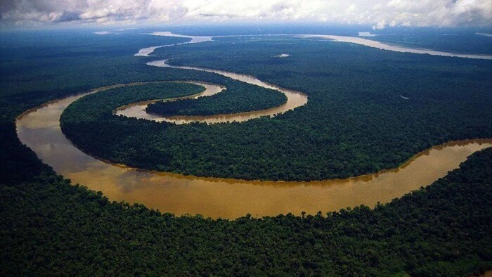
10. Congo – length 4700 km
It is the deepest river in the world (measured depth is more than 220 meters) and the second after the Amazon in terms of drainage basin size (3,680,000 sq. km).
The river originates deep in the eastern region of the Democratic Republic of Congo (DRC). It is fed by the Lualaba River, which itself is fed by the Luvoa and Luapula rivers. And those, in turn, are connected with Lake Mveru and Lake Bangwelo. The Chambeshi River also flows into Luapula.
The Congo River makes up most of the border between the DRC and its eastern neighbor, the Republic of the Congo.
The Congo River got its name from the Kingdom of Kongo, which was located on the left bank of the river's mouth. And the name Zaire, by which the river was known in the 16th and 17th centuries, comes from a Portuguese adaptation of the word nzere (“river”) from the Kikongo language.
9. Amur – 5052 km
 This majestic Far Eastern river originates in Western Manchuria where two large rivers - the Shilka and the Argun - merge. The Kerulen and Onon rivers are also considered as a source of the Amur.
The Amur flows east along the Russian-Chinese border and slowly turns into a large arc, receiving several tributaries.
The Chinese call the Amur "Black Dragon River". According to legend, the Black Dragon defeated the evil White Dragon, who was the owner of the river and in every possible way disturbed the local residents. Cupid enters.
8. Lena-Vitim – 5100 km
 The easternmost of the three great rivers of Siberia (including the Ob and Yenisei) that flow into the Arctic Ocean.
The Lena, together with its right tributary Vitim, is the eighth largest river on Earth. And the only one in the world whose channel is entirely located in permafrost areas.
The source of the Lena is a small swamp, which is located ten kilometers west of Lake Baikal.
Spring and summer floods cause the river level to rise by 10-15 meters. Because of this, its shores are sparsely populated. All surrounding buildings will be demolished during the spill.
7. Yenisei – 5238 km
 Originating from the city of Kyzyl, the Yenisei River follows a northern course into the Kara Sea, where it forms the Yenisei Bay. It serves as a natural border between Western and Eastern Siberia.
The largest tributaries of the Yenisei are: the Angara River, the Selengai River, and the right tributary of the Selenga - Ider.
6. Ob-Irtysh – 5410 km
 Two huge Siberian rivers, meeting each other, create the longest watercourse in Russia.
The Ob is shorter in length than the Irtysh. But at the same time, it is more full-flowing and in the Ob-Irtysh connection plays the role of the main river. It is formed by the confluence of two Altai rivers - Katun and Biya.
The beginning of the Irtysh River is located in the mountains on the Mongolian-Chinese border. There it is known as the Black Irtysh (or, in Chinese, Ertsisihe). And for the first 450 km of its route, the river flows through China. She faces a much longer journey—1,735 km—through the lands of Kazakhstan. And then it crosses the border with Russia in the Omsk region. And in the Khanty-Mansiysk region it meets the Ob River.
Thus, the Irtysh, although not the longest river in the world, bears the title of the longest tributary river.
5. Yellow River – 5464 km
 Translated from Chinese, this river is called “Yellow” because of the color of the silt. It is the third longest river in Asia.
The Yellow River is known as the "cradle of Chinese civilization" due to the crucial role it played in the development of Chinese culture. As with the Yangtze, the presence of human settlements near the Yellow River dates back to the Paleolithic era, and the fertile basins facilitated the growth of agricultural communities.
Before modern dams were built, the Yellow River was extremely prone to flooding. Because of this, she was given nicknames such as "The Sorrow of China" and "The Scourge of the Sons of Han." The worst flood in modern human history occurred in China in the spring of 1887 and, according to various sources, claimed from 1.5 to 7 million lives.
4. Yangtze - from 5800 to 6300 km according to various sources
 The Yangtze River holds the title of the longest river in Asia. It has played a major role in the history, culture and economy of China and continues to do so to this day. Its existence was a key factor in the emergence of human settlements, the growth of agriculture, and the development of civilization in East Asia.
Today, the prosperous Yangtze River Delta produces up to 20% of China's gross domestic product (GDP), and the Three Gorges Dam on the Yangtze River is the world's largest hydroelectric power plant. Due to the impact of human infrastructure, some sections of the river are now protected nature reserves.
3. Mississippi-Missouri-Jefferson – from 6275 to 6420 km
 This river, as its name suggests, is entirely associated with the United States of America. While each river individually wouldn't make the top five, they are grouped together as the Missouri River meets the Mississippi near St. Louis and the Missouri connects with the Jefferson River in Montana.
2. Nile – 6852 km
 Most people answer the question: “What is the name of the longest river on Earth?” will be called the Nile River. Although this "blue vein of Africa" predominantly flows through Egypt, it also passes through nine other African countries: Sudan, Eritrea, Ethiopia, Uganda, Kenya, Tanzania, Rwanda, Burundi and the Democratic Republic of Congo. Most of them belong to .
The largest lake in Africa, Lake Victoria is considered the main source of the Nile.
About 300 million people depend on this river for water supply and crop irrigation. There is even an Aswan hydroelectric complex that uses the energy of the Nile. Its construction was completed in 1970, and since then this system of structures has been used to provide electricity to the Egyptian population. It currently supplies about 20 percent of the country's electricity. The Aswan Dam also controls the summer flooding of the Nile, which threatens large-scale flooding.
1. Amazon is the longest river in the world 6992 km
 It is the largest river in the world by drainage area (6,915,000 sq. km). For comparison: the Nile drainage basin is 3,349,000 square meters. km.
 However, the debate about which is the longest river in the world - the Amazon or the Nile - does not stop. It's all about identifying the origins of the Amazon. Scientists and explorers have been trying to determine the source of the river since the 1600s. Over the years, five rivers in southwestern Peru have been given the honor of being called the source of the Amazon. Eventually, the upper reaches of the Apurimac River were considered its source.
According to the results of a study conducted in 2014, it turns out that the Amazon originates from the Cordillera mountain Rumi Cruz, located upstream of the Peruvian Mantaro River. This river then converges with the Apurimac River, and further downstream they are joined by other tributaries to form the Ucayali River. Finally, the confluence of the Ucayali and Marañon Rivers forms the Amazon.
If we take into account the latest data, then from 75 to 92 kilometers are added to the length of the Amazon. So the question of which is the longest river on Earth can be confidently answered - the Amazon.
Table of the longest rivers in the world
The full list contains 171 rivers, more than 1000 km long.
| # | River | Length (km) | Drainage basin (km²) | Countries |
|---|---|---|---|---|
| 1. | 6992 | 6915000 | Brazil, Peru, Bolivia, Colombia, Ecuador, Venezuela, Guyana | |
| 2. | 6852 | 3349000 | Burundi, Egypt, Kenya, Congo, Rwanda, Sudan, South Sudan, Tanzania, Uganda, Eritrea, Ethiopia | |
| 3. | Mississippi - Missouri - Jefferson | 6275 (according to other sources 6420) | 2980000 | USA (98.5%), Canada (1.5%) |
| 4. | 5800 (according to other sources 6300) | 1800000 | China | |
| 5. | 5464 | 745000 | China | |
| 6. | Ob - Irtysh | 5410 | 2990000 | Russia, Kazakhstan, China |
| 7. | Yenisei - Angara - Selenga - Ider | 5238 | 2580000 | Russia, Mongolia |
| 8. | Lena - Vitim | 5100 | 2490000 | Russia |
| 9. | Amur - Argun - Muddy channel - Kerulen | 5052 | 1855000 | Russia, China, Mongolia |
| 10. | Congo - Lualaba - Luvoa - Luapula - Chambeshi | 4700 | 3680000 | DRC, CAR, Angola, Republic of Congo, Tanzania, Cameroon, Zambia, Burundi, Rwanda |
| 11. | Mekong | 4350 | 810000 | Vietnam, Cambodia, Laos, Thailand, Myanmar, China |
| 12. | Mackenzie - Slave - Peace - Finlay | 4241 | 1790000 | Canada |
| 13. | Niger | 4200 | 2090000 | Nigeria (26.6%), Mali (25.6%), Niger (23.6%), Algeria (7.6%), Guinea (4.5%), Cameroon (4.2%), Burkina Faso (3.9%), Ivory Coast, Benin, Chad |
| 14. | La Plata - Parana - Rio Grande | 3998 | 3100000 | Brazil (46.7%), Argentina (27.7%), Paraguay (13.5%), Bolivia (8.3%), Uruguay (3.8%) |
| 15. | Volga - Kama | 3731 | 1380000 | Russia (99.8%), Kazakhstan (0.2%) |
| 16. | Shatt al-Arab - Euphrates - Murat | 3596 | 884000 | Iraq (40.5%), Turkey (24.8%), Iran (19.7%), Syria (14.7%) |
| 17. | Purus | 3379 | 63166 | Brazil, Peru |
| 18. | Murray - Darling | 3370 | 1061000 | Australia |
| 19. | Madeira - Mamore - Rio Grande - Rio Cane - Rocha | 3239 | 850000 | Brazil, Bolivia, Peru |
| 20. | Yukon | 3184 | 850000 | USA (59.8%), Canada (40.2%) |
| 21. | Indus | 3180 | 960000 | Pakistan (93%), India, China, disputed territories (Kashmir), Afghanistan |
| 22. | San Francisco | 3180 | 610000 | Brazil |
| 23. | Syrdarya - Naryn | 3078 | 219000 | Kazakhstan, Kyrgyzstan, Uzbekistan, Tajikistan |
| 24. | Salween | 3060 | 324000 | China (52.4%), Myanmar (43.9%), Thailand (3.7%) |
| 25. | St. Lawrence River - Niagara - Detroit - St. Clair - St. Marys - St. Louis | 3058 | 1030000 | Canada (52.1%), USA (47.9%) |
| 26. | Rio Grande | 3057 | 570000 | USA (52.1%), Mexico (47.9%) |
| 27. | Lower Tunguska | 2989 | 473000 | Russia |
| 28. | Brahmaputra | 2948 | 1730000 | India (58.0%), China (19.7%), Nepal (9.0%), Bangladesh (6.6%), India/China disputed territories (4.2%), Bhutan (2.4%) ) |
| 29. | Danube - Breg | 2850 | 817000 | Romania (28.9%), Hungary (11.7%), Austria (10.3%), Serbia (10.3%), Germany (7.5%), Slovakia (5.8%), Bulgaria ( 5.2%), Bosnia and Herzegovina (4.8%), Croatia (4.5%), Ukraine (3.8%), Moldova (1.7%). |
| 30. | Tocantins | 2699 | 1400000 | Brazil |
| 31. | Zambezi | 2693 | 1330000 | Zambia (41.6%), Angola (18.4%), Zimbabwe (15.6%), Mozambique (11.8%), Malawi (8.0%), Tanzania (2.0%), Namibia, Botswana |
| 32. | Vilyui | 2650 | 454000 | Russia |
| 33. | Araguaia | 2627 | 358125 | Brazil |
| 34. | Amu Darya - Pyanj - Pamir | 2620 | 534739 | Uzbekistan, Turkmenistan, Tajikistan, Afghanistan |
| 35. | Zhapura | 2615 | 242259 | Brazil, Colombia |
| 36. | Nelson - Saskatchewan | 2570 | 1093000 | Canada, USA |
| 37. | Paraguay | 2549 | 900000 | Brazil, Paraguay, Bolivia, Argentina |
| 38. | Kolyma | 2513 | 644000 | Russia |
| 39. | Ganges | 2510 | 907000 | India, Bangladesh, Nepal |
| 40. | Pilcomayo | 2500 | 270000 | Paraguay, Argentina, Bolivia |
| 41. | Ishim | 2450 | 177000 | Kazakhstan, Russia |
| 42. | Jurua | 2410 | 200000 | Peru, Brazil |
| 43. | Ural | 2428 | 237000 | Russia, Kazakhstan |
| 44. | Arkansas | 2348 | 505000 | USA |
| 45. | Ubangui - Uele | 2300 | 772800 | DRC, Central African Republic |
| 46. | Olenyok | 2292 | 219000 | Russia |
| 47. | Dnieper | 2287 | 516300 | Russia, Belarus, Ukraine |
| 48. | Aldan | 2273 | 729000 | Russia |
| 49. | Rio Negro | 2250 | 720114 | Brazil, Venezuela, Colombia |
| 50. | Colombia | 2250 | 415211 | USA, Canada |
| 51. | Colorado | 2333 | 390000 | USA, Mexico |
| 52. | Zhujiang - Xijiang | 2200 | 437000 | China (98.5%), Vietnam (1.5%) |
| 53. | South Red River | 2188 | 78592 | USA |
| 54. | Irrawaddy | 2170 | 411000 | Myanmar |
| 55. | Kassai | 2153 | 880200 | Angola, DRC |
| 56. | Ohio - Allegheny | 2102 | 490603 | USA |
| 57. | Orinoco | 2101 | 880000 | Venezuela, Colombia, Guyana |
| 58. | Tarim | 2100 | 557000 | China |
| 59. | Xingu | 2100 | 513000 | Brazil |
| 60. | Orange | 2092 | 973000 | South Africa, Namibia, Botswana, Lesotho |
| 69. | Kama | 2039 | 522000 | Russia |
| 61. | Salado (Parana tributary) | 2010 | 160000 | Argentina |
| 123. | Upper Mississippi | 2000 | 490000 | USA |
| 62. | Vitim | 1978 | 225000 | Russia |
| 63. | Tiger | 1950 | 375000 | Türkiye, Iraq, Syria, Iran |
| 64. | Songhua | 1927 | 524000 | China |
| 65. | Tapajos | 1900 | 487000 | Brazil |
| 66. | Don | 1870 | 425600 | Russia |
| 67. | Podkamennaya Tunguska | 1865 | 240000 | Russia |
| 68. | Pechora | 1809 | 322000 | Russia |
| 70. | Limpopo | 1800 | 413000 | Mozambique, Zimbabwe, South Africa, Botswana |
| 71. | Chulym | 1799 | 134000 | Russia |
| 72. | Guapore | 1749 | 266500 | Brazil, Bolivia |
| 97. | Marañon | 1737 | 358000 | Peru |
| 73. | Indigirka | 1726 | 360400 | Russia |
| 74. | Snake | 1670 | 279719 | USA |
| 75. | Senegal | 1641 | 419659 | Senegal, Mali, Mauritania |
| 76. | Uruguay | 1610 | 370000 | Uruguay, Argentina, Brazil |
| 77. | Blue Nile | 1600 | 325000 | Ethiopia, Sudan |
| 78. | Churchill | 1600 | 282000 | Canada |
| 79. | Khatanga - Kotui | 1600 | 364000 | Russia |
| 80. | Okavango | 1600 | 800000 | Namibia, Angola, Botswana |
| 81. | Volta | 1600 | 388000 | Ghana, Burkina Faso, Togo, Ivory Coast, Benin |
| 81. | Benny | 1599 | 133010 | Bolivia |
| 82. | Platt | 1594 | 241000 | USA |
| 83. | Tobol | 1591 | 426000 | Kazakhstan, Russia |
| 84. | Jubba - Webi-Shebeli | 1580 | 497504 | Ethiopia, Somalia |
| 85. | Putumayo | 1575 | 148000 | Brazil, Peru, Colombia, Ecuador |
| 86. | Magdalena | 1550 | 260000 | Colombia |
| 87. | Hanshui | 1532 | 175000 | China |
| 88. | Crowbars | 1500 | 95830 | DRC |
| 89. | Oka | 1500 | 245000 | Russia |
| 90. | Pecos | 1490 | 115000 | USA |
| 91. | Upper Yenisei | 1480 | 150000 | Russia, Mongolia |
| 92. | Godavari | 1465 | 313000 | India |
| 93. | Colorado (Texas) | 1438 | 103340 | USA |
| 94. | Rio Grande | 1438 | 102600 | Bolivia |
| 95. | White | 1420 | 142000 | Russia |
| 96. | Coopers Creek - Barcoo | 1420 | 297550 | Australia |
| 98. | Pelvis | 1401 | 150000 | Russia |
| 100. | Benue | 1400 | 441000 | Cameroon, Nigeria |
| 101. | Or | 1400 | 140000 | PRC, Kazakhstan |
| 103. | Sutlej | 1372 | 395000 | China, India, Pakistan |
| 104. | Yamuna | 1370 | 351000 | India |
| 105. | Vyatka | 1370 | 129000 | Russia |
| 106. | Fraser | 1368 | 233100 | Canada |
| 107. | Kura | 1364 | 188000 | Azerbaijan, Georgia, Armenia, Türkiye, Iran |
| 108. | Rio Grande | 1360 | 170000 | Brazil |
| 109. | Dniester | 1352 | 72100 | Ukraine, Moldova |
| 110. | Cauca | 1350 | 80000 | Colombia |
| 111. | Liaohe | 1345 | 228960 | China |
| 112. | Yalongjiang | 1323 | 30000 | China |
| 113. | Iguazu | 1320 | 62000 | Brazil, Argentina |
| 114. | Olekma | 1320 | 210000 | Russia |
| 115. | Rhine | 1233 | 198735 | Germany, France, Switzerland, Netherlands, Austria, Liechtenstein |
| 116. | Northern Dvina - Sukhona | 1302 | 357052 | Russia |
| 117. | Krishna | 1300 | 258950 | India |
| 118. | Iriri | 1300 | 124300 | Brazil |
| 119. | Narmada | 1289 | 98796 | India |
| 120. | Ottawa | 1271 | 146300 | Canada |
| 121. | Zeya | 1242 | 233000 | Russia |
| 122. | Juruena | 1240 | 190940 | Brazil |
| 124. | Athabasca | 1231 | 95300 | Canada |
| 125. | Elbe - Vltava | 1231 | 148268 | Germany, Czech Republic |
| 126. | Canadian River | 1223 | 124000 | USA |
| 127. | Northern Saskatchewan | 1220 | 122800 | Canada |
| 128. | Vaal | 1210 | 196438 | South Africa |
| 129. | Wider | 1200 | 149500 | Mozambique, Malawi |
| 130. | Nenjiang | 1190 | 244000 | China |
| 131. | Green River | 1175 | 124578 | USA |
| 132. | Milk River | 1173 | 61642 | USA, Canada |
| 133. | Demyanka | 1160 | 34800 | Russia |
| 134. | Chindwin | 1158 | 114000 | Myanmar |
| 135. | Sankuru | 1150 | DRC | |
| 27. | Omolon | 1150 | 119000 | Russia |
| 136. | James | 1143 | USA | |
| 137. | Kapuas | 1143 | Indonesia | |
| 138. | Gum | 1130 | 88900 | Russia Ukraine |
| 139. | Helmand | 1130 | Afghanistan, Iran | |
| 140. | Madre de Dios | 1130 | Peru, Bolivia | |
| 141. | Tiete | 1130 | Brazil | |
| 142. | Vychegda | 1130 | 121000 | Russia |
| 143. | Sepik | 1126 | 77700 | |
| 144. | Cimarron | 1123 | USA | |
| 145. | Anadyr | 1120 | Russia | |
| 146. | Jialingjiang | 1119 | China | |
| 147. | Liard | 1115 | Canada | |
| 148. | White River | 1102 | USA | |
| 149. | Huallaga | 1100 | Peru | |
| 150. | Kwango | 1100 | 263500 | Angola, DRC |
| 27. | Conda | 1097 | 72800 | Russia |
| 151. | Gambia | 1094 | Gambia Senegal Guinea | |
| 152. | Om | 1091 | 52600 | Russia |
| 153. | Chinab | 1086 | India, Pakistan | |
| 154. | Vasyugan | 1082 | 62000 | Russia |
| 155. | Yellowstone | 1080 | USA | |
| 155. | Araks | 1072 | 102000 | Armenia, Azerbaijan, Iran, Türkiye |
| 156. | Chu | 1067 | 62500 | Kyrgyzstan, Kazakhstan |
| 157. | Seversky Donets | 1053 | 98900 | Ukraine Russia |
| 158. | Bermejo | 1050 | Argentina, Bolivia | |
| 159. | Fly | 1050 | Papua New Guinea, Indonesia | |
| 160. | Guaviare | 1050 | Colombia | |
| 161. | Kuskokwim | 1050 | USA | |
| 162. | Tennessee | 1049 | USA | |
| 163. | Tura | 1030 | Tyumen region, Sverdlovsk region, Russia | |
| 164. | Western Dvina | 1020 | 87900 | Latvia, Belarus, Russia |
| 165. | Gila | 1015 | USA | |
| 166. | Vistula | 1014 | Poland, Ukraine, Belarus | |
| 167. | Loire | 1012 | France | |
| 168. | Essequibo | 1010 | Guyana | |
| 169. | Khoper | 1010 | Russia | |
| 170. | Tacho | 1006 | Spain, Portugal | |
| 171. | Rio Colorado (Argentina) | 1000 | Argentina |
Page 9 of 12
The largest, largest and longest rivers in the world. List.
|
Name |
Length (km) |
Basin area (thousand km²) |
Average water flow at the mouth (thousand m³/s) |
Highest water flow at the mouth (thousand m³/s) |
Solid waste (million tons/year) |
|
|
Amazon |
||||||
|
Nile |
||||||
|
Yangtze |
||||||
|
Mississippi - Missouri |
||||||
|
Yellow River |
||||||
|
Ob (with Irtysh) |
||||||
|
Parana (from the origins of Paranaiba) |
||||||
|
Mekong |
||||||
|
Amur (from the sources of Arguni) |
||||||
|
Lena |
||||||
|
Kongo (with Lualaba) |
||||||
|
Mackenzie (from the headwaters of the Peace River) |
||||||
|
Niger |
||||||
|
Yenisei (from the origins of the Small Yenisei) |
||||||
|
Volga |
||||||
|
Indus |
||||||
|
Yukon |
||||||
|
Danube |
||||||
|
Orinoco |
||||||
|
Ganges (with Brahmaputra) |
||||||
|
Zambezi |
||||||
|
Murray |
||||||
|
Dnieper |
5 largest, longest and largest rivers in the world by continent. Descriptions and characteristics of rivers.
1. The Amazon (6992 m) is the largest, longest and largest river in the world and South America.
Description of the Amazon River - the longest river in the world and South America.
Amazon is the absolute record holder both in length and in the fullness and area of the pool. For many years it was believed that longest river in the world is the Nile, but the latest research, carried out by comparing photographs from space and computer data processing, has refuted this long-known fact. The Amazon turned out to be 140 km longer than the Nile!
In 2011, according to the results of a global competition, the Amazon was recognized as one of the seven natural wonders of the world. And this is no coincidence. The Amazon is not only the longest, largest and largest river in the world and in South America, but also a unique place on our planet, home to more than a million species of different plants and animals. According to researchers, per 10 km² of tropical forest there are 1.5 thousand species of flowers, 750 species of trees, 125 species of mammals, 400 species of birds and countless invertebrate animals. Many of their species are not even described or identified. The Amazon and its tributaries are home to up to 2,000 species of fish, one of which is the well-known voracious predatory piranha.
The largest tropical rainforest on the planet is located in the basin of the longest river in the world. The climate here is hot and humid, all year round the air temperature fluctuates only between 25-28°C and it rains very often. There is practically no wind in the forest - the lush vegetation does not allow gusts of air to pass through. Even during a storm, only the tops of the trees sway here, and below reigns twilight and peace.
At the beginning of the 21st century, the world's longest underground river was discovered under the longest surface river in the world., flowing parallel to the Amazon at a depth of 4000 m. It originates in the Andes and flows into the Atlantic Ocean. Its unofficial name is Hamza, in honor of the scientist who discovered it. The flow speed of the Hamza River does not exceed several meters per year, and the width is about 400 meters.
Main characteristics of the Amazon River. Description of the longest river in the world in numbers. Table.
|
River name |
Amazon |
|
Length of the Amazon River: |
|
|
- from the main source of the Marañon |
|
|
- from the source of Apacheta |
about 7000 km |
|
- from the source of Ucayali |
over 7000 km |
|
Continent |
South America |
|
Brazil, Peru, Bolivia, Colombia, Ecuador, Venezuela, Guyana |
|
|
Source of the Amazon River |
Confluence of the Marañon and Ucayali rivers |
|
Source coordinates |
4°26′25″ S w. 73°26′50″ W. d. |
|
Estuary of the Amazon River |
Atlantic Ocean |
|
Mouth coordinates |
0°35′35″ S w. 49°57′22″ W d. |
|
Pool |
7,180,000 km² |
|
Water consumption |
|
|
Average annual flow |
about 7000 km³ |
|
Solid drain |
498 million tons/year |
|
River slope |
|
|
Amazon River flow speed |
|
|
Main tributaries on the right |
Jurua, Purus, Madeira, Tapajos, Xingu, Tocantins |
|
Main tributaries on the left |
Isa, Japura, Rio Negro |
|
Annual rainfall |
2. Nile (6852) - the second of the largest, largest and longest rivers in the world and the longest river in Africa.
Description of the Nile River is the second largest, largest and longest river in the world and the longest river in Africa.
Nile is a true “river of life”, as it is the only river in North Africa that crosses the sands of the Sahara without drying up. The constant water flow is carried out due to precipitation falling in the upper reaches of the river.
Almost all settlements in Egypt are located along the Nile bed and almost all economic activities are concentrated. The waters of the world's second longest river are used for irrigation and electricity production (the Nile's energy resources are estimated at 50 GW), fishing and fish farming, water supply and shipping.
The Nile originates on the East African Plateau (Kagera River), flows through Lake Victoria (some sources indicate this lake as the source of the Nile River). The exit from the plateau is characterized by an abundance of rapids and waterfalls. After the confluence of the El Ghazal River, the river is called the White Nile and flows through semi-deserts and deserts to Khartoum, receives the main tributary - the Blue Nile and, under the name Nile itself, flows to the Mediterranean Sea, at the confluence with which it forms a vast delta.
Floods in different parts of the river occur in different seasons: in the equator region - in the summer and winter seasons, in the northern part of the river - in the summer and autumn periods. Dams were built to regulate the flow of one of the world's longest rivers: Gebel Auliya on the White Nile, Aswan and Aswan High. The construction of dams protected the population from annual floods. This, on the one hand, deprived agriculture of the most important natural fertilizer - silt, but, on the other hand, it increased the area of irrigated land and made it possible to harvest three crops per year from the fields.
Main characteristics of the Nile River. Description of the second longest, largest and largest river in the world and the longest river in Africa in numbers. Table.
|
River name |
|
|
Length of the Nile River: |
|
|
– Rukarara – Kagera – Nile |
|
|
- from the lake Victoria to the Mediterranean |
|
|
Current direction |
From south to north |
|
Continent |
|
|
Countries in the drainage basin |
Rwanda, Kenya, Tanzania, Uganda, Ethiopia, Eritrea, Sudan and Egypt |
|
Largest cities |
Cairo, Khartoum, Aswan, Alexandria |
|
Source of the Nile River |
Confluence of the Rukarara and Kagera rivers |
|
Mouth of the Nile River |
Mediterranean Sea |
|
Mouth coordinates |
31°27′55″ n. w. 30°22′00″ E. d. |
|
Area of the Nile River Delta |
24 thousand km 2 |
|
Pool |
2.8-3.4 million km² |
|
Water consumption |
average 2600 m³/s |
|
Solid drain |
62 million m3/year |
|
Main tributaries on the right |
Achwa, Sobat, Blue Nile and Atbara |
|
Main tributaries on the left |
El Ghazal |
3. Yangtze (5800 km) - the third of the largest, largest and longest rivers in the world and the longest, largest and largest river in Eurasia.
Description of the Yangtze River - the third of the largest, largest and longest rivers in the world and the longest river in Eurasia.
Yangtze River originates in the eastern part of the Tibetan Plateau at an altitude of about 5600 km and flows through China from west to east, making a large turn to the south after Qinghai province. The lower course of the Yangtze passes through the southern part of the Great Chinese Plain, where the river is often divided into branches, with the width of the main channel reaching 2 km or more. In the area where it flows into the East China Sea, the Yangtze forms a large delta with an area of about 80 thousand km².
Four of China's five largest freshwater lakes drain into the Yangtze. The third of the longest rivers in the world has about 700 tributaries, the largest of which are the Yalongjiang, Minjiang, Jialingjiang, Tuo, Hanshui (Juhe).
The Yangtze River is of great cultural and economic importance to the country. This is China's main waterway. The total length of the waterways of the Yangtze basin exceeds 17 thousand km. The river is one of the world's busiest waterways. The volume of freight traffic in 2005 reached 795 million tons.
Covering a fifth of China, the Yangtze River basin is home to a third of the country's population and produces about 20% of GDP. The world's largest hydroelectric power station, the Three Gorges Hydroelectric Power Station, was built on the longest river in Eurasia.
The Yangtze River is home to a variety of animals, including several endangered species such as the Chinese river dolphin, Chinese alligators and Korean sturgeon. In the basin of the third of the largest, largest and longest rivers in the world, there are several nature reserves and part of the Three Parallel Rivers National Park, listed as a UNESCO World Heritage Site.
Main characteristics of the Yangtze River. Description of the third of the longest, largest and largest rivers in the world and the longest river in Eurasia in numbers. Table.
|
River name |
Yangtze |
|
River length Yangtze: |
5800 km (according to other sources - 6300 km) |
|
Current direction |
From west to east |
|
Continent |
|
|
Countries in the catchment area |
|
|
Largest cities, located on the longest river in Eurasia and the third longest river in the world. |
Panzhihua, Yibin, Luzhou, Chongqing, Yichang, Jingzhou, Shashi, Shishou, Yueyang, Xianning, Wuhan, Ezhou, Huangshi, Huanggang, Chaohu, Chizhou, Jiujiang, Anqing, Tongling, Wuhu, Hefei, Chuzhou, Maanshan, Taizhou, Yangzhou, Zhenjiang, Nanjing, Nantong, Shanghai |
|
Source Yangtze River |
Tibetan plateau |
|
Coordinates |
33°26′39″ n. w. 90°56′10″ E. d. |
|
Estuary Yangtze River |
East China Sea |
|
Delta area Yangtze River |
80 thousand km 2 |
|
Pool area Yangtze River |
1,808,500 km² |
|
Average annual flow |
|
|
Water consumption |
|
|
Solid drain |
280 million tons/year |
|
Main tributaries |
Yalongjiang, Minjiang, Jialingjiang, Tuo, Hanshui (Juhe) |
|
Average precipitation in the Yangtze River basin |
Description of the Mississippi River - the fourth largest, largest and longest river in the world and the longest river in North America.
Mississippi- one of the greatest rivers in the world. Together with the Missouri, it is the fourth longest river in the world and the largest, largest and longest river in North America. The Mississippi flows through ten US states from north to south. The source of the river considered to be the Nicolette Creek River (according to other sources, Lake Itasca), flows into the Mississippi to the Gulf of Mexico. River basin(the third largest after the Amazon and Congo river basins) stretches from the Rocky Mountains to the Appalachians and from the Great Lakes region to the Gulf of Mexico, occupying an area of 3268 thousand km 2, which is 40% of the area of the United States, not counting Alaska.
Length of the Mississippi River is 3950 km (according to the Great Soviet Encyclopedia) or 3774 km (Wikipedia). It takes a drop of water 90 days to travel from its source to the mouth of a river.
When talking about the Mississippi as the fourth longest river in the world, it should be kept in mind that we are talking about the length of the Jefferson-Missouri-Mississippi river system. In total, the length of the three rivers is 6275 kilometers. When it comes to the longest river in North America, various sources call either the Mississippi River (3,774 km) or its tributary, the Missouri (3,767 km). In our classification of rivers by length, we proceeded from determining the length of the river from the source of its longest tributary to the mouth. Considered this way, the Mississippi is definitely the longest river in North America.
Mississippi- a convenient waterway from the Gulf of Mexico to the central parts of the mainland, an important transport artery of the United States, connecting the developed industrial and agricultural areas of the country. The rivers of the Mississippi system are of great economic importance. The total length of the basin's shipping routes is over 25 thousand square meters. km. A number of large power plants have been built on tributaries of the Mississippi.
River feeding mixed, snow and rain. The right tributaries bring mainly meltwater formed by snowmelt in the Rocky Mountains, while the left tributaries feed the Mississippi with rain and stormwater. The Mississippi regime is characterized by spring-summer floods and stormy rain floods.
The longest, largest and largest river in North America is divided into three sections, the boundaries of which are where its largest tributaries, the Missouri and Ohio, flow into the Mississippi.
On the upper section the river flows through small lakes, overcoming rocky rifts and rapids in many places, the most significant of which are near the cities. Minneapolis (St. Anthony Falls), Davenport and Keokak. From Minneapolis to the mouth of the Missouri, the river is locked; there are more than 20 dams in this section.
On the middle section The fourth longest river in the world flows predominantly in one channel. The width of the river valley, limited by steep slopes, is 15-20 km. In the middle section, the Mississippi has an interesting feature: for 150-180 km, the dirty, muddy waters of the Missouri flow next to the relatively clear water of the Mississippi without mixing.
On the lower section The Mississippi River flows through a vast valley, gradually widening from 25 to 70 km. The river bed is winding, with numerous branches and oxbow lakes, forming in the lower reaches a labyrinth of channels, oxbow lakes, and vast floodplain swamps that are flooded during floods. At the end of the delta, the longest, largest and largest river in North America branches into 6 main relatively short branches 20-40 long km, flowing into the Gulf of Mexico.
Main characteristics of the Mississippi River. Description of the fourth of the longest, largest and largest rivers in the world and the longest river in North America in numbers.
|
River name |
Mississippi |
|
River length Mississippi: |
3950 km (according to other data - 3774), together with Missouri - 6420 km (according to other data - 6275) |
|
Current direction |
From North to South |
|
Continent |
North America |
|
Countries in the catchment area |
USA (98.5%), Canada (1.5%) |
|
Source of the river Mississippi |
Nicollet Creek |
|
Source coordinates |
47°14′23″ n. w. 95°12′27″ W d. |
|
Mouth of the river Mississippi |
Gulf of Mexico |
|
Mouth coordinates |
29°09′13″ n. w. 89°15′03″ W d. |
|
Delta area Mississippi River |
OK. 32 thousand km 2 |
|
Pool area Mississippi River |
3268 thousand km 2 |
|
Average annual flow |
about 600 m/km |
|
Water consumption |
7-20 thousand m³/s |
|
Solid drain |
400 million tons/year |
|
Right tributaries Mississippi River |
Minnesota, Des Moines, Missouri, Arkansas, Red River |
|
Left tributaries Mississippi River |
Wisconsin, Illinois, Ohio |
5. Yellow River (5464 km) - the fifth of the largest, largest and longest rivers in the world and the second longest river in Eurasia.
Description of the Yellow River - the fifth of the largest, largest and longest rivers in the world and the second longest river in Asia.
Yellow River- one of the greatest rivers in the world, is the second longest river in Asia and the fifth longest river in the world. The name of the river means "Yellow River" in Chinese. The yellow color of the river's waters is given by the abundance of sediment, of which there is so much in the river that the sea into which it flows is called the Yellow Sea. The Yellow River ranks first in the world in terms of sediment volume (1.3 billion tons/year).
The Yellow River begins in the eastern part of the Tibetan Plateau at an altitude of over 4000 m, it flows through lakes Orin-Nur and Dzharin-Nur, spurs of the Kunlun and Nanshan mountain ranges. When crossing the Ordos and the Loess Plateau, in its middle course it forms a large bend, then through the gorges of the Shanxi Mountains it enters the Great Chinese Plain, along which it flows about 700 km before flowing into the Bohai Bay of the Yellow Sea, forming a delta in the confluence area. According to various sources, the length of the river is from 4670 km to 5464 km, and the area of its basin is from 745 thousand km² to 771 thousand km².
Nutrition method Yellow River: rain, in the mountainous part of the basin also snow. The fifth of the longest, largest and largest rivers in the world has a monsoon regime during summer floods with a rise in water levels of up to 5 m on the plains and up to 20 m in the mountains. For flood protection A system of dams with a total length of more than 5,000 km was built along the river. Dam breaks led to catastrophic floods, accompanied by large-scale destruction and changes in the river bed (the maximum change in the river bed was about 800 km). Due to the incredible catastrophic floods, the Yellow River received the nickname “The Mountain of China.” It is known that over the past two thousand years, the Yellow River has overflowed its banks more than a thousand times, broken through dams, and at least 20 times significantly changed the trajectory of its bed. In 1931, during the Yellow River flood, according to various estimates, from 1,000,000 to 4,000,000 residents of the North China Plain died.
But despite this, the Yellow River basin provides about 140 million people drinking water and water for irrigation. A number of hydroelectric power stations were built on the river. Through the Grand Canal, the fifth largest, largest and longest river in the world is connected to the Huaihe and Yangtze Rivers.
The Yellow River flows through a total of seven modern provinces and two autonomous regions, namely the following (from west to east): Qinghai, Gansu, Ningxia Hui, Inner Mongolia, Shaanxi, Shanxi, Henan and Shandong. The mouth of the Yellow River is located in Kenli County (Shandong).
The river is usually divided into three parts- upper, middle and lower reaches. The upper course of the river passes through the northeast of the Tibetan Plateau and the Loess Plateau of northwestern China; the middle course includes the valley between Ordos and Shaanxi and the gorges further downstream; the lower course of the river passes through the Great Chinese Plain.
Main characteristics of the Yellow River. Description of the fifth of the longest, largest and largest rivers in the world in numbers.
|
River name |
Yellow River |
|
River length Yellow River: |
According to various sources, from 4670 km to 5464 km |
|
Current direction |
From west to east |
|
Continent |
|
|
Countries in the catchment area |
|
|
Largest cities |
Lanzhou, Yinchuan, Wuhai, Baotou, Luoyang, Zhengzhou, Kaifeng and Jinan |
|
Source Yellow River |
Tibetan plateau |
|
Source coordinates |
34°59′33″ n. w. 96°03′48″ E d. |
|
Estuary Yellow River |
Yellow Sea |
|
Mouth coordinates |
37°47′03″ n. w. 119°18′10″ E. d. |
|
Delta area Yellow River |
127 thousand km 2 (submitted by G.E. Reinika and I.B. Singh) |
|
Pool area Yellow River |
from 745 thousand km² to 771 thousand km² |
|
Water consumption |
2000 m³/s |
|
Solid drain |
1.3 billion tons/year |
|
Right tributaries Yellow River |
|
|
Left tributaries Yellow River |
Wudinghe, Fynhe |
This was the article " The largest, largest and longest rivers in the world. List and descriptions.» Continue reading:
Until recently, it was written in all school textbooks that the longest river in the world is the Nile. Its length is 6670 kilometers. However, already now many scientists give the palm to another river - the Amazon.
This happened for several reasons. Namely, the Nile became shorter after the Aswan Dam was built on it in 1960. Well, besides this, the Amazon River has several tributaries, these are the Ucayali and Marañon. And more recently, it began to be traced from the source of Ucayali. And from this point the length of the South American river exceeded 7 thousand kilometers. For comparison, this is the distance from Berlin to New York.
Fresh sea
However, the Amazon is not only the longest river in the world. She holds several more records. For example, it is the largest in terms of basin size and the deepest (special thanks to the heavy rainfall for this). Of course, the Amazon is the most water-bearing river in the world. The river throws approximately 200 thousand cubic meters of water into the Atlantic Ocean. By the way, in 30 seconds a reservoir can provide absolutely every inhabitant of the planet with one liter of fresh water. It turns out that a fifth of all fresh water that enters the World Ocean comes from the Amazon. And the force with which fresh water flows into the Atlantic displaces salt water at a distance of about 200 kilometers. Only for this, the famous Italian navigator Vicente Yañez Pinzón gave the Amazon another name - Mor Dulcea, which translates as “Fresh Sea”.
By the way, when you first meet a river, you actually want to call the Amazon a sea. In some places its width is so enormous that it is impossible to see the opposite bank. And the flood makes the longest river even wider. At such moments the width reaches fifty kilometers. Well, the depth is not so impressive; in the largest places it ranges from 50 to 80 meters. In narrow ones it is 130 meters. The Amazon is located parallel to the equator. This leads to the fact that it is strongly influenced by the summer season, in both hemispheres. Therefore, the right and left tributaries are replenished with water. And the water level can fall and rise. Experts compare the life of the Amazon to the pulsation of a giant heart. Throughout the year, the water level can fluctuate from 9 to 12 meters. In general, the Amazon is filled with more than five thousand tributaries. The right Madeira and the left Rio Negro deserve special attention. If you add up the length of all the branches of the champion river, then its length will be more than 25 thousand kilometers.
Royal flora and fauna
The Indians have always admired the beauty of the mighty Amazon and called it nothing less than the “queen of rivers.” The waters of this longest river on the planet pass at the foot of the Peruvian Andes, come into contact with the dense tropical forests of Ecuador and Bolivia, and also flow near the “floating islands” of Colombia, plantations of cassava bushes and guarana in Brazil. On the banks of the Amazon, in the plant kingdom, among a dense tangle of palm leaves and vines, live anacondas and jaguars looking for their victims. And vice versa, tapirs hide from predators, capybaras graze, monkeys play and frogs croak. Well, in the muddy waters of the river (due to the silt that is carried by the rapid flow of water) more than two thousand species of fish live. Overall, the Amazon has approximately 30 times more fish species than all European rivers. Among them are the famous piranhas, stingrays and river sharks (all these are “underwater wolves”). There are two types of river dolphins here, you can meet a giant otter, as well as an alligator and turtles. By the way, during the rainy season, pink river dolphins from the main river move into the flooded forest, where they can be found swimming or hunting near the trees. It is noteworthy that on one hectare of the river’s tropical forest you can find more than 200 varieties of trees. And that's not all, according to research, there can be up to 72 different species of ants on one tree. By the way, the longest river on Earth fully lives up to its name.

This has been happening since the time of the Spanish conquistadors (this is the 15th-16th centuries). Then the conquerors were extremely surprised by the strength of Indian women. They fought alongside men and were inferior to them in little way. Therefore, the mighty river was named after their tribe “de los Amazonas”. The river does not allow you to approach it because of its steep banks. They are not just clayey and steep, but swampy and sometimes flooded. The warlike and violent nature of the Amazon is also indicated by the driftwood floating with the current, the disgusting mud and constant whirlpools.
Taming of the Shrew
Man has been trying to conquer the great Amazon for a long time. Some do it out of sport, and some do it for selfish reasons. In the latter case, we are talking about cutting down the jungle, which is present in abundance on the banks of the river. Man mercilessly destroys nature, thereby depriving the planet of vital energy. Others behave much more harmlessly. The simplest example of conquest of a river is the story of Martin Strela. This young man showed his strengths and earned hero status in a documentary called Big River Man. The film was released in 2009. A fearless swimmer from Slovenia covered 5,268 kilometers of water in just 66 days. Thanks to this, the athlete was included in the Guinness Book of Records, thereby showing the strength of the human spirit and mutual understanding of nature and man.
By the way, there is not a single bridge across the Amazon River, about 7 thousand kilometers long. The only one appeared only in 2010. The crossing was made through one of the tributaries of the longest river - the Rio Negro. The bridge connects the major Amazon port of Manaus and the city of Iranduba. The length of this structure is quite impressive - 3 kilometers and 595 meters.
Breathe down your back
The length of the Nile is immediately behind the Amazon. Well, next on the list of the longest rivers are the Mississippi (with Missouri). This river in North America stretches for 6 thousand 420 kilometers. Next comes the Yangtze, its length is 5800 kilometers. Well, Ob closes the top five record holders. The Siberian River, including the Irtysh, stretches for 5,410 kilometers. By the way, this is the longest river in Russia.
Subscribe to our channel in Yandex.Zen
The earth's continents, like blood vessels, are permeated with large and small rivers that supply the territories with fresh water. The exception is, perhaps, ice-bound Antarctica. Human civilizations have long arisen in the deltas of the largest rivers. Currently, they provide the lives of hundreds of millions of our contemporaries. As usual, for hundreds of years there has been a fierce dispute between different countries about which river can bear the title of the longest river. In order to scientifically add a couple of tens of new kilometers to the length of “their” river, the government sometimes equips serious scientific expeditions, sparing no expense to equip them.
Disputes about which is the longest river in the world still flare up from time to time.
Despite herculean efforts from competitors in recent years, South American scientists have managed to secure a strong lead in this informal Amazon competition. It is the longest river in the world.
For a very long time, the African Nile was a worthy competitor to the South American river. But, in 1960, the Egyptians sacrificed it to technological progress and the safety of farmland. Several large dams, built as elements of the Aswan hydroelectric complex, shortened the giant river. Today the length of the river is up to 6670 kilometers. Now the biblical river is in second position on the list of the longest rivers on earth.
The starting position of the Amazon is located at the beginning of its tributary, the Ucayali River in highland Peru. If we calculate the Amazon from this point, then the length of the equatorial river exceeds 7000 kilometers. The area of the majestic river delta is approaching 100 thousand kilometers. And this is also an absolute record, indicating that the Amazon is the largest river in the world. It also has the largest river island in the world - Marajo. The area of this island is comparable to the territory of Switzerland. The Amazon has several more record-breaking achievements. Being the most water-bearing river on the planet, in half a minute it could fill an imaginary pool capable of supplying each of the 7 billion earthlings with one liter of fresh water.
20 percent of all fresh water entering the world's oceans comes from the Amazon. Freshwater flows in the river gain such speed that they throw salty sea water 200 kilometers from the coast. One of the unofficial names of the Amazon is the Fresh Sea. And the river suits him well. The width of the reservoir in many places does not allow you to see the opposite shore. During periodic floods, the Amazon becomes even wider. The distance between its banks can reach 50 kilometers. To reach the bottom of the Amazon you have to dive to 50-80 meters.

Of the more than a thousand known tributaries of the Amazon, the two largest ones stand out: Madeira and Rio Negro. The Indian tribes inhabiting the Amazon floodplain have always worshiped her power, calling her the queen of rivers. The longest river in the world, born at the foot of the Andes in Peru, gains strength in the Bolivian and Ecuadorian jungles, and is saturated with aquatic fauna in the area of the Colombian floating islands. At the end of its journey, the Amazon irrigates Brazilian guarana plantations.
On the lush Amazonian shores, life rages in a whirlpool of palm leaves and flexible vines. Giant anacondas and graceful jaguars tirelessly search for those who will become their food. Herbivorous tapirs and good-natured calibars try in every possible way to avoid meeting them. High above the ground, under a green roof, curious primates scurry about.
In the watery depths of the Amazon, muddy from the silt carried by the river, 2,000 species of fish live (in many European rivers the fish kingdom is about 30 times poorer). The most famous fish of the Amazon are the so-called underwater wolves. These include the voracious piranhas, stingrays and river sharks. Here you can see river dolphins and giant otters. With the onset of the rainy season, dolphins move up the river and invade the flooded jungle, frolicking and hunting among the submerged trees. The Great River is the source of most aquarium fish.
In the waters of the leader among the largest rivers in the world, you can meet a very interesting creature. This is an electric eel that is capable of generating electric currents of up to 1300 volts. Indians from coastal villages found a permanent source of income by catching electric eels for extreme aquarists. To avoid electrical injury during dangerous fishing, cunning aborigines prudently drive livestock into the Amazon. After some time, the stored charge in eels runs out, making them completely safe.

The Amazon flora is so rich that you can count up to two hundred species of trees on one hectare of floodplain. Moreover, each tree is a haven for many insects.
The Amazon received its generally recognized name during the Age of Discovery from the Spanish conquistadors. The armored adventurers were amazed by the strength of the women from the Indian tribes. They went into battle alongside men and proved to be a worthy opponent, reminiscent of the Amazons from ancient Greek myths. The Spaniards named the river in honor of the legendary warriors.
This is a very harsh river. In most areas it is impossible to approach the Amazon. It has steep and steep clay banks. In addition, sometimes they are swampy. The largest river is saturated with non-navigable sections, abounding in mud and whirlpools.
Despite the fantastic length of the Amazon, not a single bridge has yet been built across it. Only in 2010 did humanity manage to cross the largest tributary of the Amazon, the Rio Negro. This bridge, 3 and a half kilometers long, connected the port of Manaus and the Brazilian town of Iranduba.
Having discovered the longest river in the world, settlers are constantly trying to conquer it. Most do this using barbaric methods, uncontrollably cutting down the invaluable tropical forests growing along the banks of the Amazon.
Martin Strela is one of the few who managed to tame the longest river without the use of special means. A Slovak swimmer managed to swim over 5,000 kilometers in the waters of the Amazon in 66 days. In 2009, a documentary film was made about his phenomenal journey - “The Man of the Big River”. Martin's achievement was included in the famous Guinness Book of Records.
The Amazon forests are considered to be the lungs of the planet. According to scientific research, the age of the forests of the longest river is approximately 100 million years, and the area is comparable to the territory of Western Europe. The flora of the largest river grows so densely that only 1 percent of the light sent by the sun reaches the earth's surface.
In 2011, scientists discovered the twin of the longest river in the world, the Rio Hamza River. It carries its waters almost parallel to the giant river, but deep underground, 4 kilometers from sunlight. The length of the Rio Hamza River is about 6000 kilometers.

The longest rivers in the world are located on different continents. The longest rivers on earth include the Nile, Yangtze and Yellow River. The length of the West Siberian Ob River allows it to take fifth place in the list of the longest rivers in the world. The Ob River is the largest in Russia. Close to the Russian heart, the Volga is the longest river in Europe. The length of this river is 3 and a half thousand kilometers.
The Puerto Princesa River is the largest cave river in the world. The Philippine river, hidden by stone arches, has a rather modest length - only 8 kilometers. But every year the beauty of the cave vaults attracts thousands of curious tourists.
Rivers entangle all of Russia like a web. If you count them all down to the smallest one, you get over 2.5 million! But the vast majority of them don’t even have names, so it’s better to pay attention to the largest rivers in the country, not forgetting what you can catch in them, because there are a lot of fishermen in Russia.
1. Lena (4400 km)
The longest river in Russia, and at the same time in Siberia, is the Lena. It is also respectable by world standards, since it ranks at the top of the ten longest waterways in the world. Lena takes its beginning from a small lake near Baikal, winds a lot through the mountainous Baikal region until it turns north and rushes to the Laptev Sea, where it forms an extended delta. Together with the latter, it has a length of 4,400 km with a basin area of 2.5 million square meters. km, the water flow in the lower reaches is 16,350 cubic meters. m/s. This is the longest Russian river, flowing entirely through the country, and the largest in the world, completely passing through the territory of permafrost. The Lena still remains one of the cleanest rivers in the world. Man has not yet been able to change its course; he has not built a single dam, hydroelectric power station or other energy structures. In areas remote from human activity, you can still drink water directly from the river.
2. Irtysh (4248 km)

Like most of the large rivers of Siberia, the mighty Irtysh from the depths of the Asian continent heads north until it flows into the Ob, being its main tributary. Their joint water system stretches for 5,410 km, which makes it the seventh longest on Earth. But this is not even the main attraction of the Irtysh, but the fact that it has become the longest tributary in the world, since its own length is 4248 kilometers. In this category, it is significantly inferior to second-place Missouri, which has a length of “only” 3,767 kilometers.
Translated from the Turkic language, Irtysh means “digger,” and this reflects the nature of the river, which very often changes its course, undermining the banks. The Irtysh is fed by meltwater and tributaries. But now floods rarely occur here, since several hydroelectric power stations have been built here, the dams of which regulate the release of water.
The territory of Russia is huge, so it is not surprising that dozens of waterfalls are scattered across it, in its most diverse corners. Some of them are so...
3. Ob (3650 km)

In the northeast of Asia, in the Altai Territory, near the administrative border with the Altai Republic, two mountain rivers Biya and Katun merge, resulting in the formation of a powerful full-flowing river Ob, the name of which has still not been revealed. The Ob crosses Western Siberia from south to north and after 3,650 kilometers flows into the Kara Sea, more precisely, into a long (800 km) gulf called the Gulf of Ob. The Ob has the largest basin in Russia, occupying almost 3 million square kilometers, and in terms of fullness it is second only to the Yenisei and Lena, bringing 12,300 cubic meters of water to the mouth every second.
4. Volga (3531 km)

The great Russian river Volga has over 150 tributaries; few other rivers on the planet have as many. Taking into account the average flow speed of 4 km/h, it is calculated that the water in it reaches the mouth in 37 days. This river even has its own holiday - Volga Day is celebrated on May 20. The entire Volga basin is located on the territory of Russia, it crosses the territories of four republics and 11 regions of the country, and only one small branch of it, Kigach, turns into the territory of Kazakhstan.
And the source of the Volga is located on the Valdai Hills, in the Tver region near the village of Volgoverkhovye. Although not the largest in Russia, the Volga is nevertheless the largest river in Europe. Its basin extends over a third of the European territory of Russia, occupying 1,855 million square meters. km, and water consumption is 8060 cubic meters. m/s. 9 hydroelectric power stations with reservoirs were built on the Volga; half of the country’s agriculture and industry are served with its water.
5. Yenisei (3487 km)

The Yenisei River appears after the confluence of the Big Yenisei (Biy-Khem) and the Small Yenisei (Kaa-Khem). The Yenisei flows for almost 3.5 thousand kilometers only through the territory of Russia, and before that it winds through Mongolia for another 600 kilometers. At the end of the journey, it flows into the Yenisei Bay, which belongs to the Kara Sea. The source of the Yenisei is located near the geographical center of Asia near the city of Kyzyl, in which there is even an obelisk reminiscent of this.
In terms of basin area (2.58 million sq. km), the Yenisei is second only to the Lena; its water consumption is also large - 19,800 cubic meters. m/s. In three places it is blocked by powerful hydroelectric power stations: Sayano-Shushenskaya, Krasnoyarsk and Mainskaya. As for the name of the river, it is associated either with the Tungus word “enesi”, which means “big water”, or with the Kyrgyz “enee-say”, that is, mother river.
The mighty, stormy Yenisei is especially notable for its ice drifts. During the winter, a powerful ice shell grows on the river, from which the river is freed for at least a month. Thousands of tons of ice rush along the river, forming jams here and there that block the flow. As a result, the river overflows its banks and floods the surrounding area. At one time, different cities had to feel the power of this water element - Yeniseisk, Krasnoyarsk, Igarka and Minusinsk.
As long as humanity can remember its history, there have been daredevils who were attracted by majestic mountain peaks. Romance of climbing creatures...
6. Lower Tunguska (2989 km)

This is another Siberian river, which is the right tributary of the Yenisei. The Lower Tunguska flows through the Irkutsk region and Krasnoyarsk region. It winds for a long time along the middle part of the Siberian Plateau until it comes to the Putorana Plateau. Due to the large number of rapids and whirlpools, navigation along the Lower Tunguska is severely limited. Back in 1911, plans were made to connect the Lena and Lower Tunguska near the city of Kirensk, since here they converge to a distance of 15 kilometers, however, the Lower Tunguska flows almost 85 meters above the Lena, and is also not navigable in this place. Therefore, the construction of a connecting canal between them was abandoned due to the high cost and inexpediency of the project.
7. Amur (2824 km)

The Amur River is international - it flows through the lands of Russia, China and Mongolia, and flows into the Sea of Okhotsk in the area of the Amur Estuary. The length of the Amur is 2824 kilometers, and the basin area is 1.855 million square meters. km with a water consumption of 10900 cubic meters. m/s. The Amur flows through 4 different climatic zones: semi-desert, steppe, forest-steppe and forest; 30 different nationalities live on its banks. There is no clarity regarding the origin of the name of the river, but the most common version is from the Tungus-Manchu words “damar” or “amar”. The Chinese call it the Black Dragon River, but in our country the Amur symbolizes the Far East and Transbaikalia.
8. Vilyui (2650 km)

The longest and largest left tributary of the Lena, flowing through the Krasnoyarsk Territory and Yakutia, is called Vilyuy. It has served man since ancient times, giving him water and food. A couple of hydroelectric power stations were built on it. When intensive industrial development of Siberia began, the environmental situation in the Vilyuy basin worsened, causing concern to the indigenous residents.
On our planet there are areas where a person experiences special sensations: a surge of energy, euphoria, a desire to improve or spiritually...
9. Ishim (2450 km)

Ishim is the left and longest tributary of the Irtysh; it passes through the territory of Kazakhstan and Russia. According to popular legend, the name “Ishim” comes from the name of the son of the Tatar Khan, Ishim, who drowned in a previously nameless river. But there is also a Tatar word “ishimak”, meaning “destroying”. There are two reservoirs on Ishim that are of great economic importance: the local population uses water from them and irrigates fields and gardens.
10. Ural (2428 km)

In the European part of Russia, the Ural River is one of the largest. It descends along the southeastern Black Sea-Caspian slope, running 2,428 kilometers from its very source to its confluence with the Caspian Sea. The area of the river basin is 220 thousand square meters. km. The Ural is a very winding river, it is usually divided into three sections: from the source to Orsk, the middle from Orsk to Uralsk and the lower from Uralsk to the very mouth. A whole network of reservoirs has been built on this river, which provide much-needed water for industry and agriculture.
Hands to Feet. Subscribe to our channel at

